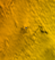
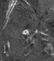
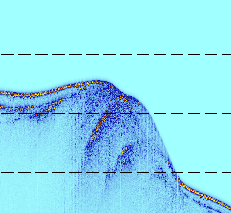
The second leg of our cruise will be focused on core retrieval. We’ll be using a piston coring system and expect to be able to recover cores up to 10 m long. After a few days of analyzing the large majority of different seismic and sonar data we have from our work so far, the team got together to discuss which areas contain good evidence for viable coring locations. When selecting these locations, we think back on one of the goals of this project which is to “study the role slope failures (underwater landslides) play in building a passive margin (area beyond the continental shelf)”. This is different than an active margin where plate tectonics plays a significant role. The images below all highlight different aspects of the same feature (~50 meter/~150 ft mound) almost 1000 meters under water. The first image shows our bathymetry (seafloor topography) data. The second image shows the backscatter (reflectivity of the seafloor) data. Using these two images, we can see a small mound-like feature that has high reflectivity (white). The third image is our seismic data at the same location. The area circled in black shows a reflection that doesn’t follow the stratigraphy (layer orientation) of the surrounding sediment. This could be evidence of fluid migration and a potential cause of slope failure. The last image shows sub-bottom profiler data in the same area where the yellow/orange areas have higher reflectivity. Collecting cores from areas such as this will allow for further testing, and eventually some answers to our hypotheses. Coring begins in less than a week, so we expect today’s discussion to continue until final sites are chosen.