Community and Regional Planning graduate students in my Zoning and Health Practicum course during the 2023-2024 academic year studied the role of planning in exposure residents of certain neighborhoods to air pollutants known to be linked to asthma. They produced a GIS Storymap summarizing their work which you can find here. In particular, their analysis and maps show how current planning practices (or lack of planning authority or environmental protections) will combine with growth projections to increase the number of residents exposed to dangerous pollutants because they live too close to the source of this pollution.
Here is a summary of their findings and recommendations:
In Travis County, Texas, hospitalizations for pediatric asthma are 60% higher than for US children overall. And there is considerable evidence of racial disparity: compared to rates for white children, 8 times as many black children, and 2.5 times as many Latinx children compared were hospitalized for asthma. People coming to the emergency room for treatment for asthma are also concentrated in a subset of Austin neighborhoods.
Income and racial segregation in the region have increased the likelihood of disproportionate exposure to air quality hazards. Various factors that together are described as increasing social vulnerability likely compound the effects of exposure in areas with higher shares of residents of color and may compound health impacts of exposure.
Air quality data maps reveal that exposure to two key pollutants that affect the lungs—particulate matter (PM) and sulfur dioxide (SO2) is not evenly distributed throughout the region. PM 2.5 is most concentrated along the path of I-35 and in parts of East Austin, PM 10 in the same central areas and in large swaths of east Austin, while SO2 is most heavily concentrated east of I-35.
Data on asthma rates by census tract show rates are highest east of I-35 and in some neighborhoods adjacent to the highway.
The siting of environmental hazards may play a key role in these disparate patterns since scientific studies have found that proximity to hazards is linked to various illnesses.
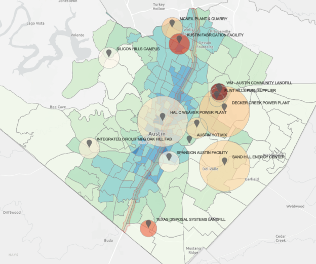
Using buffers created based on available studies, we mapped how projected population growth will likely expand within the high exposure zones for a subset of sources. Our maps also reveal several areas where exposure to multiple known sources of dangerous emissions will occur, which may compound the health effects for residents. For example, we estimate that 10,000 new residents will move within the exposure zone surrounding the Sand Hill Energy Center. There is less research on health effects of living near concrete plants than for other hazards–although evidence on the negative health consequences for working on such sites is strong.
In principle, Texas cities can use zoning to prevent the co-location of residential areas and environmental hazards. In contrast, Texas county governments have limited power to guide the siting of residential development. In addition, Municipal Utility Districts can be formed by developers to facilitate new subdivision development in unincorporated areas. It has become increasingly difficult for cities to annex outlying areas, thus much new growth will take place in areas where local government cannot prevent encroachment of residential growth into zones exposing residents to hazardous air quality.
Our case studies elucidated the ways that environmental hazards and residential areas were placed next to each other.
· In Del Valle, the lack of coordinated governance of development and siting of environmental hazards has created a pattern of cumulative exposure to air quality hazards. The presence of hazards undermined property values thus encouraging more growth, as prices rise in Austin.
· The Austin Community Landfill is under the purview of Travis County which lacks the ability to control residential encroachment around it. Its location immediately adjacent to parts of the City of Austin and within the Manor Independent School District highlighted the problems that come when jurisdictions are not able to collaborate to prevent residential encroachment and siting of schools, daycares, and other sensitive land uses nearby. The median year built of homes within a mile distance of the landfill was 2008–long after the opening of the landfill in the 1970s.
· Finally, the construction of I-35 and its proposed expansion highlight the problems resulting from the original zoning and subsequent public actions that allowed for a mix of residential and industrial uses to be sited in the neighborhoods to its east. Our analysis revealed the disproportionate siting of multifamily housing within the hazard zone surrounding the highway. In fact, sensitive uses make up one third of land within the buffer around the highway’s current footprint, and many residential units have been permitted in this area in recent years. Yet expansion appears to be moving forward absent consideration of likely impacts to proximate current and future residents and builds on existing disparate patterns of exposure.
In sum, current residents living within the City of Austin, its ETJ, and surrounding Travis County are at risk of long-term exposure to dangerous pollutants such as PM and SO2 in places where they live, work, and play. Local jurisdictions are not doing enough to prevent residential growth near areas with high levels of exposure.
Recommendations
While our work focused on identifying the problems that have resulted from current growth trends and planning practices, we offer the following recommendations for further study. While these focus on land use strategies to prevent the exposure of residents to high levels of pollutants, the City and its transportation partners in the region and at the state and federal level should also continue and increase their efforts to reduce emissions associated with driving. These strategies include urban design and transportation planning to create more walkable, mixed use districts, and facilitate greater reliance on transit or non-motorized modes of travel, and also the shift to greater use of electric vehicles.
City of Austin
- The city should develop strategies to mitigate the impact of environmental hazards on existing residents and to prevent the encroachment of residential areas into danger zones around hazards. Mitigation strategies might include air quality monitoring and heightened filtration requirements in danger zones and disclosure of air quality hazards to prospective or current residents in such areas. To prevent co-location of residential or other sensitive uses and air quality hazards, zoning and permitting processes could prohibit siting such uses in danger zones, and discourage siting or expansion of dangerous uses within buffers of such uses.
- The city should partner with local researchers and experts to document the health risks associated with existing air quality hazards and to monitor changes in conditions in particular areas over time.
Travis County
- Travis County should identify areas within the County most and least suited for residential development, based on scientific studies of the health risks posed by proximity to specific hazards. Suitability analysis is a tool often used to identify areas for land conservation and could be adapted for this purpose.
- Travis County should use existing County plans for the expansion of infrastructure to guide residential growth away from areas identified as least suitable. Future ASMP and CAMPO mobility plans should highlight the location of these polluting sites and site infrastructure to direct growth outside of their buffers.
TCEQ
- Improve transparency and access to information on permit applications, and emission levels.
- Allow for genuine public input from residents living within areas where health data indicates likely exposure to dangerous pollutants.
State of Texas
- Set buffer zones around sources of hazardous pollutants and prohibit residential development within these buffers. If data is not available, commission studies of air quality and health from scientific experts in air quality hazards and health and provide them access to necessary data on emissions and health outcomes.
- Give counties greater authority to regulate the siting of residential development and require them to avoid proximity to known health hazards.
- Facilitate annexation of ETJ areas so that cities can use their zoning authority and permitting processes to prevent co-location of residential areas and environmental hazards.
- Remove fiscal penalties for annexation of ETJ areas so that cities can provide necessary services to annexed neighborhoods.
A call to action
We have outlined the ways that current development patterns have resulted in exposure of residents in some parts of Austin and Travis County to air quality hazards that research has linked to health effects. Without action to change current trends the number of residents exposed to dangerous air will grow and bring with it serious health consequences for residents. Now is the time to act to guide growth to avoid putting homes, daycares, schools, and other sensitive uses in harm’s way.