In 2016, a drought on the Marshall Islands caused over 16,000 people to suffer from extreme water shortages. The government declared a state of emergency well after freshwater wells had already been contaminated by seawater, leaving thousands to drink from coconuts for survival. This picture is unfortunately not uncommon for this area of the world. Only three years earlier, an even more significant drought impacted 30% of the Marshallese population. These climate events are out of their control: however, there are still some steps that governments can take to prepare themselves and their citizens for the impacts of saltwater intrusion, which might be coming even sooner than previously predicted.
In my earlier articles, I discussed the importance of acquiring bathymetry data for low lying islands and the varying effects that rising seas can have on atoll erosion and accretion. Both of these articles have informed my next topic; saltwater intrusion in atolls and vulnerable population’s access to freshwater. I might suggest reading these two articles first, particularly “Shrinking Shores” to get an introduction to ocean dynamics and their impact on vulnerability.
Saltwater Intrusion
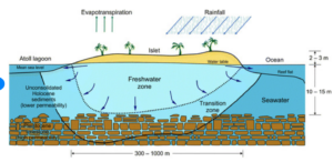
For most islands in Oceania, fresh water is available from wells that tap into the land’s freshwater zone or freshwater lens (Figure 1). Because saltwater weighs more than freshwater, rainfall that leaches through the ground “floats” on top of the seawater creating two layers of water with a ‘transition zone’ where they meet. On the most vulnerable islands, atolls, the land and therefore freshwater lens is very thin, making those who live on these islands particularly vulnerable to water shortages. The freshwater lens on atoll islands is generally a function of rainfall, recharge, land permeability, and island width, including the reef flat plate.

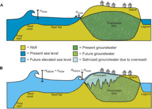
Saltwater intrusion is the process of seawater mixing with and eventually consuming the freshwater lens. When waves of the heavier saltwater overwash on the island (Figure 2B), the saltwater will leach down into the freshwater lens and create increased salinity in drinking water. The saltwater will eventually separate back downward, however, the recovery speed of the freshwater lens is dependent on the amount of saltwater overwashed and the permeability of the land. After disaster events, including cyclones and tsunamis, as well as “blue sky” inundation events, recorded recovery times varied anywhere from one month to 26 months depending on their severity.

As discussed in my previous article, sea-level rise is associated with increased wave energy and accelerated breakdown of the reef crest. This will lead to additional wave energy that exacerbates not only erosion effects but also overwash effects. Therefore, keeping wave heights low either by preserving the reef or installing engineering solutions can mitigate saltwater intrusion.
Modeling Salt Water Intrusion for Resiliency
Many sea-level rise models fail to incorporate increased wave energy in predicting future atoll habitability. Additionally, changes in rainfall patterns and strengthening storms from climate change will create different rates of salination for different islands. Both of these factors make modeling saltwater intrusion and vulnerability difficult over a large area, as extensive data needs to be collected to accurately model inundation extent.
One study on the Marshallese atoll island Roi Namur implemented sophisticated modeling techniques to incorporate wave energy into their projections. They used bathymetry and topological data, oceanographic and hydrogeologic models combined with climate change and sea-level rise projections to model scenarios of saltwater intrusion in a variety of scenarios. In order for these models to be accurate, they also need to be calibrated with salinity data from a real inundation event, making collecting baseline data important for future model accuracy.
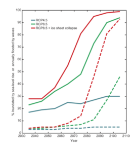
This same study found that traditional sea level rise models (dashed lines for each RCP scenario in Figure 3) were significantly lower in their estimation of the percent of the island inundated over time. Although difficult to execute without the proper data, this study could be used as a model for how future research can more accurately predict the extent of saltwater intrusion on an individual island basis. This data is spatial and includes predictions on how waters will mix, making it especially helpful for informing future planning for disaster events and could assist in locating precisely where vulnerability hotspots might be for freshwater availability.

Resiliency Actions
As discussed in my previous article, not all islands will be impacted in the same way by climate change. Some may see increased coral growth and sedimentation, while others will erode more rapidly. Similarly, not all islands’ salinity will change at the same rate and solutions to freshwater availability should be specific to each island. Collecting bathymetry and groundwater-salinity data can help us predict problems and plan for disasters, and can also help us model solutions that can be tailored to each island.
Engineering Considerations
Unfortunately, many of the engineering solutions implemented on atolls have been counterproductive to resiliency efforts (see this article for more information on the negative consequences of infrastructure investment). One difficult tradeoff in the decision to install engineering solutions for saltwater intrusion is that they often require dredging; harming the reef crests and flats that are so important for wave dissipation and therefore saltwater overwash in the first place. While sea walls can be rebuilt, these corals can take 100,000 to 300,000 years to fully develop again. There is, then, a tipping point at which the benefits of building a sea wall outweigh those of maintaining a productive reef. More data and advanced modeling can only help us in determining the cost-effectiveness of these engineering solutions.
Collecting and Preserving Fresh Water
Building capacity for freshwater collection, storage and preservation will make islanders more resilient to the impacts of saltwater intrusion. Some methods that have already been implemented in parts of Oceania are building reservoirs, dispersing solar water purifiers, building rain storage capacity (see this video), and the rationing of fresh water. These methods can be maximized by using better models to predict when and where they will be needed most. Agriculture and food systems are one area in particular that could benefit from these predictions (For more on saltwater intrusion and food systems, see this article).
Another complication with implications for disaster preparedness is that in the event of a drought, vulnerable populations will likely move towards locations that still have potable water available. During the 2013 and 2016 droughts in the Marshall Islands, for example, residents fled to the capital where freshwater was still accessible. It is safe to predict that people will likely continue to move to make sure they have access to water. Unfortunately, if vulnerable groups become more concentrated in certain parts of an island, this increases the likelihood of contaminating the little remaining groundwater in that area. Climate change could worsen this with inundation events or more intense storms flooding septic systems.
Conclusion
Freshwater availability will likely be the determining factor in atoll habitability. Costly alternatives to on-island freshwater sources will not likely be sustainable in the long term, making mitigating salt-water intrusion and preserving freshwater even more imperative. In order to predict when and where we should apply solutions, we need to be sure that our models are as accurate as possible by accounting for wave overwash and collecting thorough and precise data. These actions, as well as equipping citizens with the tools and knowledge to collect and preserve freshwater, can be implemented to adapt and prepare for the inevitable changes coming.


