

Informal settlements are growing throughout the world. Their exact locations and populations are difficult to determine, however, given their inherently spontaneous and sporadic nature. Informal settlements are also uniquely vulnerable to environmental hazards, as they often consist of poor quality, semi-permanent structures on marginal land and have limited access to essential infrastructure.
As climate change increases the risk of environmental disasters any plan to increase Oceania’s resiliency must include informal settlements. Collecting and maintain datasets, however, is also uniquely difficult in Oceania.
The first step, therefore, to including Oceania’s vulnerable informal settlements is finding a cost-effective way to locate them and estimate the number of residents. Recent research using a machine learning model and freely available satellite imagery may provide the answer.
The Growth of Informal Settlements
The proportion of the global population living in slums or other informal settlements has increased since 2014 after dropping since 2000. As a result, over 1 billion people currently live in slums or informal settlements. By 2030, the UN estimates that 3 billion people will be without adequate housing.
The relative and absolute growth of informal settlements is the result of population growth, urbanization, and migration that outpace cities’ abilities to provide adequate, affordable housing and resilient urban infrastructure.
Our cities are growing more quickly than our housing supply.
Informal settlements in Oceania
Information is scarce on the growth of informal settlements in Oceania. The limited data that do exist are disparate and without context – the three data points available through the Sustainable Development Goal’s open database are for the entirety of Oceania in 2000 and 2016 and for Fiji in 2016.
The relative lack of data on Oceania is expected. Datasets are difficult to collect and maintain in Oceania and the relative populations are tiny compared to populations centers in the rest of the world. For example, in the UN Sustainable Development Goal 2019 Status Report, Sub-Saharan Africa and Asia account for 80% of the population living in informal settlements. In absolute numbers, 238 million people in Sub-Saharan Africa and 597 million in Asia live in informal settlements. In comparison, the combined populations of this project’s target countries is 2.7 million people.
There is, however, evidence from specific countries and urban areas about the growth of informal settlements in our study area. Informal settlements in Honiara, Solomon Islands, are growing at 12% per year and now include around 40% of Honiara’s population.
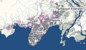
The situation in Fiji’s greater Suva area is similar. 494,252 people, half of Fiji’s population, lives in the Suva area, which has grown 16% since 2007. Much of this growth has been in splintered, informal settlements on the border of existing urban areas. Estimates on the number of people currently living in informal settlements range from 76,613 to 98,850 and estimates on the number of informal settlements in the Suva area are not absolute, ranging from 72 to 172.
The situations in Fiji and the Solomon Islands are not unique in Oceania. The United Nations Economic and Social Commission for Asia and the Pacific, in its Ocean Cities Policy Guide, recognizes “a rapid rise of people living in informal settlements” across Oceania’s cities due to the pace of urbanization and the lack of affordable housing growth.
Disaster Vulnerability in Informal Settlements
Informal settlements present an array of challenges related to disaster preparedness and vulnerability. First, informal settlements are often located in marginal areas exposed to environmental hazards. This includes low-lying coastal areas, flood plains, riverbanks, and steeply sloped hills. Second, housing is typically poor quality and less durable than permanent structures. Finally, informal settlements are generally underserved by water, sanitation, and hygiene infrastructure.
Oceania’s informal communities, by their nature, undermine the region’s resiliency to climate-related disasters.
The Challenge of Identifying Informal Settlements
Informal settlements are inherently unplanned. They are not contiguous, easily delineated residential areas. Rather, they exist on the peripheries of existing urban areas and are splintered throughout Oceania’s cities.
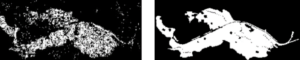
Take Suva for example. In the maps below, the estimated informal settlements areas are in pink.
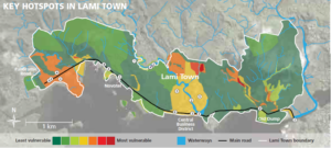
Lami Town, a settlement on the edge of Suva bordered by Mangrove forests and prone to flash flooding during heavy rainfall and inundation during storm surges.
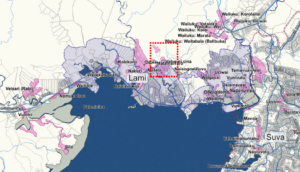
Informal settlements, particularly the one noted by the dotted red box, are in Lami Town’s most vulnerable areas.
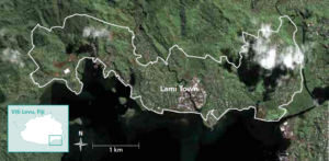
Finally, a satellite image of Lami Town highlights the practical challenge of identifying and delineating informal settlements. There are no clear boundaries between the formal city and informal areas.
Identifying Oceania’s Informal Settlements
There are several ways to estimate informal settlements and their populations. They involve varying levels of expense, commitment, and technology.
One promising method uses freely available satellite imagery from the European Commission’s Sentinel-2 satellite to map informal settlements. This method uses a machine learning algorithm to recognize, on a pixel-by-pixel basis, whether each pixel in a satellite image represents an informal settlement. The result is a map of all the pixels in the region that the algorithm identified as part of informal settlements. The method can also estimate population by estimating the number of people who live in each pixel.
This method shows significant promise for Oceania, as it allows researchers to map informal settlements without visiting them, which would be prohibitively expensive. Using this method in Oceania would require a coordinated technological effort and on-the-ground verification of initial data. However, once researchers validated the method, this method could identify informal settlements and estimate their populations remotely, which would facilitate efforts to improve resiliency in Oceania’s informal settlements.
This is not a magic bullet, however. The method is relatively new (it was originally published in 2019) and would require ground truthing initial findings to ensure results were accurate. Additionally, the availability of satellite data can limit the model. If the open-source satellite imagery is unavailable or not detailed enough, higher resolution satellite imagery can cost hundreds of thousands of dollars.
Beyond Machine Learning
Most alternatives suffer the same pitfalls: they require localized, intense effort. While such methods may help identify and map informal settlements in specific areas, they are too resource intense to use in Oceania’s disperse, remote cities.
UN Habitat provides an excellent example of a mixed methods approach. Their informal settlement analysis of Fiji was the source of the images of Suva and Lami Town in this post and required on-the-ground data collection in the specific target areas. Data collection was extensive, including in-depth interviews, household surveys, community mapping, and boundary mapping with GPS devises. It is not economically feasible to complete such in-depth analysis across Oceania.
Moving Forward
Informal settlements, while difficult to quantify, are likely growing in Oceania. They are uniquely vulnerable to climate-related disasters and must be a focus of any plan to increase the region’s resiliency to climate change.
They are also difficult to precisely identify at scale across Oceania.
With the recent advances in machine learning analysis of free satellite imagery, however, it may be possible to map the region’s informal settlements without ground-truthing each location. Quantifying the challenge of informal settlements in Oceania is the first step towards making the settlements less vulnerable to climate disasters.