• Skip to primary navigation
  • Skip to main content
  • Skip to primary sidebar
UT Shield
The University of Texas at Austin
  • Research
  • People
  • Facilities
  • Publications
  • Our Github
  • Contact

Autonomous Platforms

January 12, 2026, Filed Under: AugRe, Autonomous Platforms, Defense, Nuclear, Research

AugRE

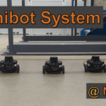
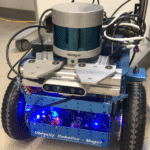
AugRE (Augmented Robot Environment) is a scalable mixed reality-based human-robot teaming system that enables users to easily command, control, and supervise large multi-agent unmanned ground and aerial vehicles. The current system enables multiple users to collaborate with up to 50 robotic agents simultaneously in unknown indoor and outdoor environments. The system features real-time localization, an efficient by directional communication layer, and spatially aligned holographic representations that enable users to easily visualize and interact with real-time robot sensor data. Check out the AugRE project page to learn more: https://utnuclearroboticspublic.github.io/Augmented-Robot-Environment/

  • Github (https://utnuclearroboticspublic.github.io/Augmented-Robot-Environment/)
  • Publications:
    • AugRE: Augmented Robot Environment to Facilitate Human-Robot Teaming and Communication: https://ieeexplore.ieee.org/document/9900721
    • Augmented Reality User Interface for Command, Control, and Supervision of Large Multi-Agent Teams: https://arxiv.org/abs/2401.05665
    • AugRE Video AugRE: Augmented Robot Environment to Facilitate Human-Robot Teaming and Communication
  • Videos: Youtube Playlist

November 12, 2025, Filed Under: Autonomous Platforms, Nuclear, Research

Minibots

Multi-Robot Collaborative Mapping w/ Remote Mobile Agents:

This project contributes to a broader initiative to develop a comprehensive hardware and software solution for routine radiation surveying in nuclear facilities. The Minibot system includes a central server computer that serves as the coordination and processing hub, and a team of compact, low-powered, cost-effective robot agents. Each agent features a differential drive platform and a small footprint, enabling navigation through confined and hazardous areas where other robots cannot safely operate, such as under furniture and along narrow corridors.

Coordinated by the server, the agents continuously offload environmental data from onboard 2D and 3D LiDAR sensors. The server then executes collaborative SLAM and 3D mapping algorithms to produce detailed maps of the environment, which other robots use for task planning and execution.

  • Thesis: https://doi.org/10.26153/tsw/51571
  • Video: https://www.youtube.com/watch?v=9eT9DMGf5lk

September 17, 2025, Filed Under: Archived, Autonomous Platforms, Nuclear, Research

Condition Monitoring of Dry Storage Canisters

Dry Cask Storage

Summary: Over 90% of SNF dry cask storage systems in the United States use welded dry storage canisters (DSCs). Typically, these canisters represent the confinement barrier in the dry storage system preventing any release of SNF or radioactive noble gases to the environment. As the dry storage terms of SNF are extended, DSC monitoring issues become more important for safe operation of the dry cask storage systems. The objective of this research program is to develop a technology to enable the next generation of “intelligent spent nuclear fuel (SNF) dry storage canisters (DSCs),” that is, canisters with integrated sensing and processing capabilities to enable real-time state awareness of the DSC. This project was funded by DOE NEUP

Collaborator: Dr. Salvatore Salamone (UT Austin), Orano TN, Idaho National Lab

  • Wall climbing robot youtube playlist
  • Elgavish, E., and Pryor, M., “Development and Validation of a 3d Force and Moment Balancing Simulation Software for Evaluating Wall Climbing Robots on Varied Surfaces,” ASME/DETC, November 2024. (doi link)

September 17, 2022, Filed Under: Archived, Autonomous Platforms, Nuclear, Research

Self Exploration and Mapping for Indoor Robotic Applications

Magni Robot

Summary: The purpose of this effot is to develop a robotic system that is fully capable of autonomous survey tasks with little to no human interaction. The system uses a Veloydne VLP-32 LIDAR sensor and an Intel RealSense D435 camera to simultaneously map the environment and avoid all obstacles autonomously. Combination of these sensor to detect positive, negative, and overhead obstacles results in 3D object detection, which is then used to create a 2D map using SLAM mapping algorithms.

Primary Sidebar

Recent Posts

  • Digital Twin Augmented Reality – Radiation in AR
  • AugRE
  • Affordance Templates for Complex DOE Robotics Tasks
  • AugRe Drone Integration
  • Autonomous Alpha Radiation Sensing and Reporting

UT Home | Emergency Information | Site Policies | Web Accessibility | Web Privacy | Adobe Reader

© The University of Texas at Austin 2026