The LLILAS Initiative on Participatory Mapping and the Struggle for Land and Resources is building a network of scholars, practitioners, and community leaders throughout the Americas. Participants are engaged in various aspects of participatory mapping and bring a diversity of experiences and perspectives, based on specific national and regional contexts. This expanding group pursues its continuing dialogue through conferences and workshops, collaborative field research, and joint publications.
Bjørn Sletto
Charles Hale
Helena Andrade
Geronimo Barrera
Joe Bryan
Beatriz Bustos
Alexandra Lamiña
Davi Pereira Jr
Wendy Pineda
Carlos Salamanca
Richard Smith
Marla Torrado
Astrid Ulloa
Alfredo Vitery
Alfredo Wagner
Andrea Christina Wirsching
Eglee Zent
Emmanuel Farias Junior
Bjørn Sletto, coordinator
Dr. Sletto is associate professor in the Community and Regional Planning Program, School of Architecture, University of Texas at Austin. His research focuses on indigenous land rights, social justice, and environmental planning in Latin America. During the past decade, he has lived and worked in indigenous villages and border cities in Venezuela, investigating environmental conflicts and land rights struggles and conducting participatory mapping projects with the Pemon in the Gran Sabana and Yukpa in the Sierra de Perijá. Dr. Sletto works closely with partner institutions in South America to further international scholarship on representational politics and social justice in vulnerable communities, while teaching Geographic Information Systems, environmental justice, and Latin American planning and development.

Mapping of Yukpa traditional territory in Toromo, Zulia, Venezuela.
Charles Hale
Dr. Hale is SAGE Sara Miller McCune Dean of Social Sciences, University of California, Santa Barbara, and former Director of the Teresa Lozano Long Institute of Latin American Studies at The University of Texas at Austin. Internationally respected in his field of activist anthropology, Dr. Hale focuses on race and ethnicity, identity politics, and consciousness and resistance. He is a recent past president of the Latin American Studies Association (LASA), and the author of Más que un Indio: Racial Ambivalence and Neoliberal Multiculturalism in Guatemala and Resistance and Contradiction: Miskitu Indians and the Nicaraguan State, 1894–1987. He is also editor of Engaging Contradictions: Theory, Politics, and Methods of Activist Scholarship.
Top
Helena Andrade
Helena Andrade is an anthropologist specializing in popular education and community development. She is co-founder of Fundación La Minga, Colombia, where she participated in the development and first implementation of “social cartography.” The techniques of social cartography were used to accompany the process of participatory planning, land-use planning and territorial demarcation in southwestern Colombia. Andrade is currently with Fundación Trópico, where she works on participatory mapping with indigenous people and public administration in protected areas in the Valle de Cauca, Colombia.

Gerónimo Barrera
Gerónimo Barrera de la Torre is PhD student in the Latin American Studies program at the University of Texas at Austin. He has conducted work in Chatino communities in Oaxaca, México, focusing on the ways landscape is conceptualized and represented through Chatino language. Currently, he is studying the environmental programs implemented by the government for forest conservation in the same area in Oaxaca, focusing on their consequences for Chatino local knowledge and practices around forest use. Gerónimo does not see participatory mapping simply as a tool to depict local knowledges, but rather as a means of co-production of knowledge by fostering articulation of different experiences, histories, worlds and struggles.
Top
Joe Bryan
Dr. Joe Bryan, Department of Geography at the University of Colorado, works on indigenous politics in the Americas, human rights, and critical cartography. His most recent work addresses the role of community-based mapping in a 2001 ruling by the Inter-American Court of Human Rights. The case concerned a land claim brought by the indigenous Mayangna community of Awas Tingni against the Republic of Nicaragua, and set an important legal precedent for recognizing indigenous land rights. He has also worked on issues related to indigenous land rights in Honduras, Chile, Ecuador, and the western United States.
Top
Beatriz Bustos
Dr. Beatriz Bustos, assistant professor of geography at the Universidad de Chile, conducts research at the intersection between environmental policy and development geography. She is particularly concerned with conflicts between national development strategies, local development and social justice. Currently she is drawing on participatory mapping methods to investigate community rights and spatialities surrounding the salmon industry in the Los Lagos region in Chile. She wants to understand strategies used by local actors to introduce their demands into the environmental agenda, and how these strategies are transforming the material landscape which they aim to protect from the impacts of neoliberalism.
Top
Alexandra Lamiña
Alexandra Lamiña is a PhD student in Latin American Studies at the University of Texas at Austin and a recent graduate from the dual master’s degree program in Community and Regional Planning and Latin American Studies, also at the University of Texas at Austin. She has worked since 2010 with the Kichwa from the Ecuadorian Amazon to support processes of territoriality and political representation. Her main areas of involvement include social mobilization, community participation, participatory mapping, and ethnography. Currently, she investigates indigenous vis-á-vis modernist planning in the Ecuadorian Amazon, focusing on the challenge posed to modern planning by indigenous ontologies and the opportunities for forging new forms of planning that incorporates indigenous epistemologies.
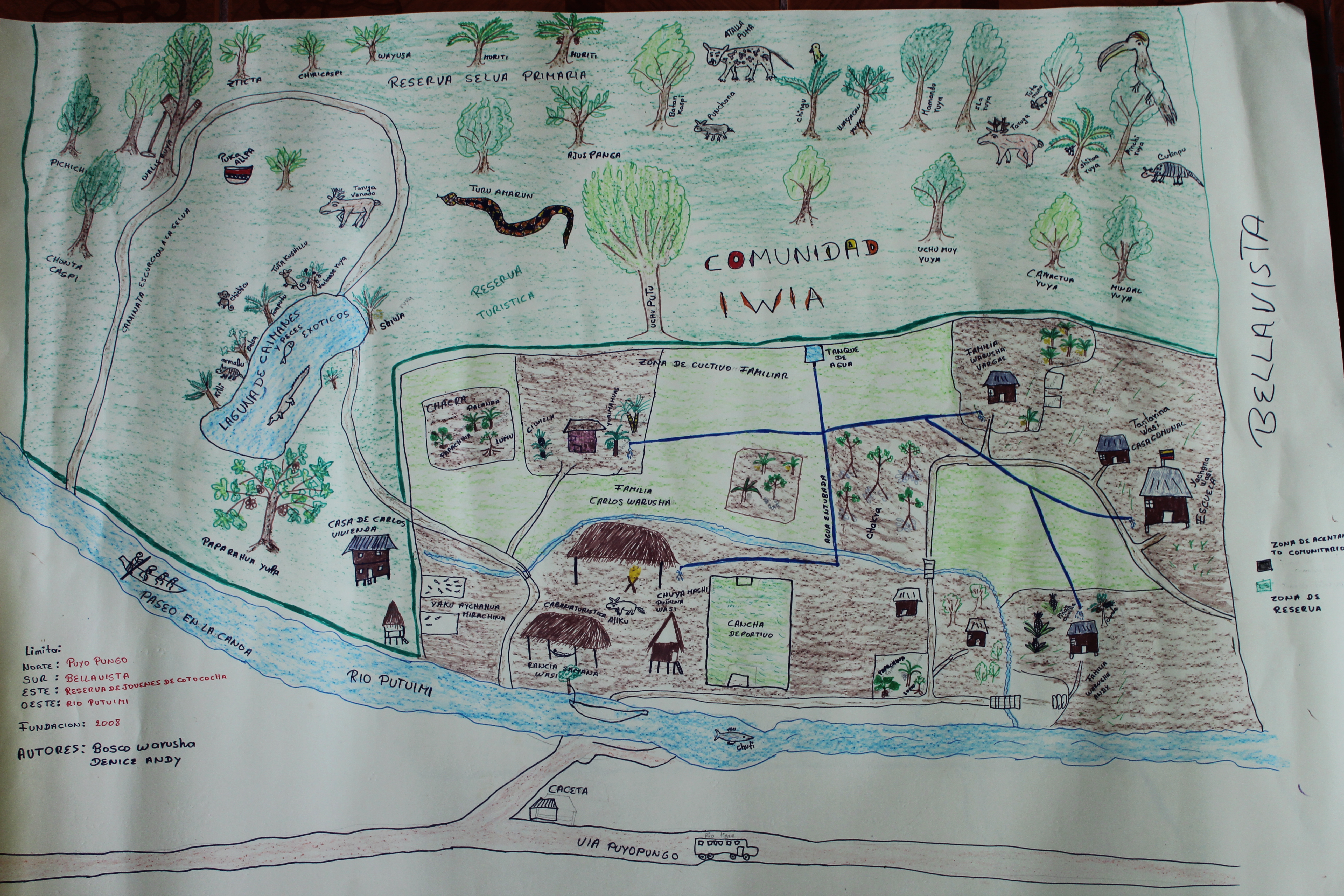
Participatory map of Comunidad Iwia, Asentamientos Comunitarios Kichwa, Comuna San Jacinto del Pinto, Pastaza, Ecuador.
Davi Pereira Jr
Davi Pereira Jr. is a PhD student in the Latin American Studies program at the University of Texas at Austin. He has been conducting research using participatory mapping (social cartographies) for the past twelve years with peoples and traditional communities in Brazil. Through his work at the research institute Nova Cartografia Social da Amazônia in Manaus he has contributed to the collective development of more than 20 social maps. In these maps, indigenous peoples, Quilombolas, Terreiros, Women Quebradeiras de Coco, and other groups have been able to express their political engagement and social struggles, including conflicts, implications of conquests, and demands for collective rights including territorial rights.
From bottom left: Dorival Santo, Davi Pereira, Luis Lima and Ednald Padinh.
Wendy Pineda
Based in Lima, Perú, Wendy Pineda is Technical Director for Territory for la Federación de Comunidades Nativas del Río Corrientes (FECONACO). FECONACO is the representative organization of three indigenous groups (Achuar, Kichwa y Uraninas) in the Corrientes river watershed, which is an area under severe threat from oil exploration. FECONACO’s goals include the defense of territorial and resource rights, promotion of respect for indigenous culture and values, and community development in member communities. She directs the Programa de Capacitación y Vigilancia Territorial Independiente, which draws on participatory mapping and GPS technologies to map adverse impacts of the oil industry.

Participatory mapping in indigenous communities of Rio Corrientes, Perú. Photo courtesy Wendy Pineda.
Carlos Salamanca
Carlos Salamanca is an Argentinian architect with a doctoral degree in anthropology from École des Hautes Études en Sciences Sociales (EHESS), Paris, France. He has been conducting research on space, history and power since 2001, focusing on indigenous land rights in Argentina. He currently works as assistant professor in the master’s program in Antropología Social y Política de la Facultad Latinoamericana de Ciencias Sociales (FLACSO), Buenos Aires.
Top
Richard Smith
Dr. Richard Smith is Executive Director of the Instituto del Bien Común (IBC), a Peruvian NGO established in 1998 which works with rural and indigenous communities in the Andean Amazon region to promote sustainable development of communal natural resources. IBC works to further community-based land-use planning and development, community-based environmental conservation and management, and respect for indigenous rights, culture, and knowledge. During the past 12 years, Dr. Smith and IBC have been mapping the boundaries of the 1,400 indigenous communities of Perú with the goal of protecting indigenous lands from extractivist and development interests. He also continues working on a project to document oral histories of places, events and ancestors of the Yánesha people.

Participatory field mapping with Instituto del Bien Común, Perú. Photo courtesy Richard Smith.
Marla Torrado
Dr. Marla Torrado earned her PhD from the Program in Community and Regional Planning at The University of Texas at Austin. She had previously conducted research in Makushi communities in southern Guyana, combining remote sensing analysis and GIS with ethnography to document the social impacts of the construction of a national road. For her doctorate, she studied the effects of the expansion of genetically modified soybean in rural communities in Argentina, drawing on participatory mapping methods and gender-based analysis to assess the role of women-based movements in community-based resistance to these agri-business projects. She participated in the forum on participatory mapping at the Universidad de los Andes in June 2011 and is co-author of the conference proceedings, Cartografia participative y derechos al territorio y los recursos (LLILAS 2012; ed. Bjorn Sletto).
Top
Astrid Ulloa
Dr. Astrid Ulloa is associate professor in the Department of Geography at Universidad Nacional, Colombia. Since 1984, she has worked with different indigenous groups (arhuaco, emberá-chami, emberá, kogui) to further community-based environmental management processes through participatory mapping, while also conducting research on indigenous conceptualizations and representations of space and territory. In addition, Dr. Ulloa continues to conduct research on territorial dimensions of indigenous autonomy and the challenge to their territoriality from extractivist regimes of appropriation.
Top
Alfredo Vitery
Alfredo Vitery is an indigenous leader from the Nation of the Kichwa de Pastaza, Ecuador, which is the largest indigenous community in the Ecuadorian Amazon. He currently works with indigenous groups in lowland Ecuador to gain territorial recognition under the 2008 constitution. Vitery is particularly concerned with issues of indigenous political representation in national governance, and the demarcation and protection of indigenous lands by municipal administrations.
Top
Alfredo Wagner
The anthropologist Alfredo Wagner is director of the Proyecto Nueva Cartografía Social de la Amazonía in Manaus, Brasil. The goal of this project is to develop a “new cartography” for Amazonian peoples and traditional communities and in so doing, represent the diversity of cultural expressions and collective identities of social movements associated with these communities. The group of investigators includes 15 PhDs in anthropology, law, geography, biology and sociological history, and 41 students. The project has developed 50 working documents since its inception in 2005.
Top
Andrea Christina Wirsching
Christina Wirsching is a PhD student in the Program in Community and Regional Planning at The University of Texas at Austin, and co-organizer and lead graphic designer for the workshop on participatory mapping, climate change, and forest rights at UT-Austin in November 2010, and the forum on participatory mapping at the Universidad de los Andes in June 2011. Wirsching’s research interests include social and environmental justice in planning and planning processes, especially within marginalized communities; dynamics and implications of dialogue, power, narrative and identity in planning; and diversity in planning education and practice.
Top
Eglee Zent
Dr. Eglee Zent is professor at the Centro de Antropología at the Instituto Venezolano de Investigaciones Científicas, Caracas, Venezuela, whose research focuses on local knowledge and ethnobotany of Amazonian indigenous peoples. She and her partner Stanford Zent have conducted participatory mapping and training workshops among the Jodï in Bolivar State, Venezuela, and written extensively on participatory mapping in Venezuela and elsewhere in Latin America, including as co-editor with Hortensia Caballero Arias of a special issue on participatory mapping in Antropologica.
Top
Emmanuel Farias Junior
Emmanuel Farias Junior holds a Ph.D. in Social Anthropology and a master’s degree in Society and Culture in the Amazon from the Federal University of Rio Grande do Sul, Brazil. He is now Associate Professor of the Department of Social Sciences, Center for Applied Social Sciences-CCSA, and the Postgraduate Program in Social and Political Cartography in the Amazon, at the State University of Maranhão, Brazil. He has also been a researcher at the New Social Cartography Project of the Amazon in Manaus, Brazil, since 2005. For the past decade and a half, he has been working as a partner with indigenous people and quilombolas on social cartography projects in support of their struggle to preserve collective identities, ethnic territories, and traditional natural resource management.