• Skip to primary navigation
  • Skip to main content
  • Skip to primary sidebar

Ransom Center Magazine

  • Articles
  • Sections
    • Art
    • Books + Manuscripts
    • Conservation
    • Exhibitions + Events
    • Film
    • Literature
    • Photography
    • Research + Teaching
    • Theatre + Performing Arts
  • Print Edition

A childhood gift inspires a lifelong passion for India and map-collecting

December 5, 2022 - Aaron T. Pratt

A childhood gift inspires a lifelong passion for India and map-collecting

Charting a Path

Sixty maps and other prints of South Asia and the surrounding region have recently arrived at the Ransom Center at The University of Texas at Austin in honor of former professor Susan G. Hadden. Generously donated by her husband, James Hadden, Jr., the newly acquired Susan G. Hadden Collection of Early Maps of India contains maps dating from 1540 to around 1880, and together they track developments in cartography and the rise of European trade, colonization, and ultimately empire in the region.

The Hadden collection’s earliest map is a two-page woodcut that was printed as part of Sebastian Münster’s Geographia (Basel, 1540), a Latin version of Ptolemy’s widely printed and adapted Geography. It is the first printed map dedicated to illustrating the Asian continent as a whole. In it, only four cities within India have been identified, all on the western coast, all sites of early Portuguese settlement and/or trade.

One of the most significant maps in the collection was first published only 30 years later: a copy of Abraham Ortelius’s map of Southeast Asia from a later sixteenth- or early seventeenth-century edition of his Theatrum orbis terrarum, the book famously recognized as the first modern atlas. Printed from an engraved copperplate, Ortelius’s map stands in contrast to Münster’s, naming dozens of ports along the full coast of the Indian peninsula along with numerous cities in the interior.
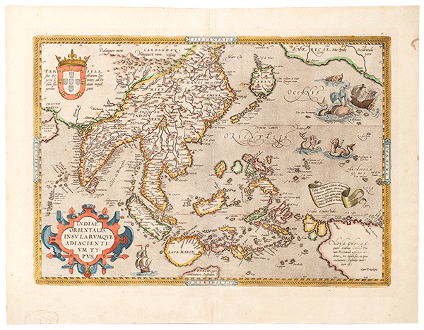
Early map of India
Abraham Ortelius, Indiae Orientalis insularumque adiacientium typus [map], in Theatrum orbis terrarum (Antwerp: s.n., between 1578 and 1603). Susan G. Hadden Collection of Early Maps of India, Harry Ransom Center.
As the maps advance from the seventeenth century through the eighteenth and into the nineteenth, they show further European encroachment and then colonial rule at the hands of the British East India Company and, ultimately, the British government itself. One map from 1851, for instance, uses hand-coloring to highlight the division of “British India” into the three Presidencies of Bengal, Madras, and Bombay and differentiates between towns that were home to military and civilian stations. It also includes the path of a proposed rail system, one with routes that differ from the ones ultimately built.

The maps’ collector, Susan G. Hadden (1945–1995), was born in Austin, Texas. Not long after her birth, her family moved across the country when her father, Nathan Ginsburg, took a faculty position in physics at Syracuse University. Once grown, Hadden obtained degrees from Radcliffe College and the University of Chicago, ending up back in Austin as a professor in the LBJ School of Public Affairs and the Center of Asian Studies at The University of Texas. She worked at the university from 1979 until her death.
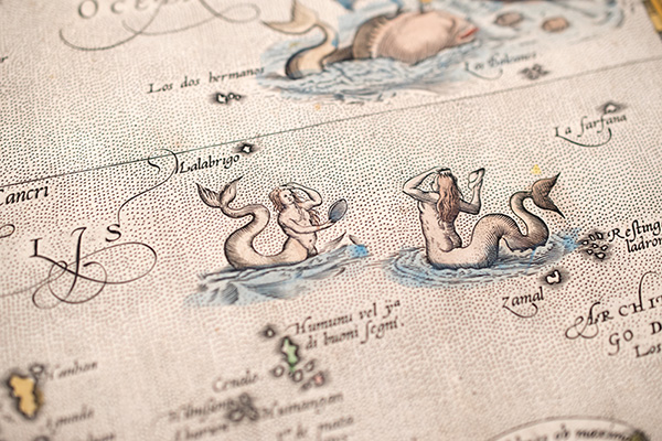
Mermaids on a map
Details of sea creatures and mermaids from Abraham Ortelius, Indiae Orientalis insularumque adiacientium typus [map], in Theatrum orbis terrarum (Antwerp: s.n., between 1578 and 1603). Susan G. Hadden Collection of Early Maps of India, Harry Ransom Center.
The M.A. and Ph.D. in political science that she earned at the University of Chicago brought her to a fruitful career working in public policy on a wide range of issues. During the late 1980s and early 1990s, she became a recognized expert in telecommunications, serving as an adviser to former Vice President Al Gore on public access to the internet. She never forgot, though, the passion that had been sparked when she received a gift from India while in grade school. At Radcliffe, she studied Sanskrit with Harvard University professor Daniel H. H. Ingalls, and she published research on pollution control in India well after pivoting to policy.

When Hadden was approaching the end of her time as a doctoral student, her parents took an extended vacation in Europe. While traveling, they purchased maps to give their daughter as a present when she finished her degree. Hadden went on to build a significant map collection, using what she had amassed to decorate her home and, once in Austin, her office.

The articles, catalog clippings, purchase receipts, and correspondence with map dealers that accompany the collection show Hadden’s diligence in learning about maps—and acquiring them—from the early 1970s and into the early 1980s. A 1977 letter from a bookseller appears to indicate that Hadden at one time hoped to compile a bibliography describing every published map of India.
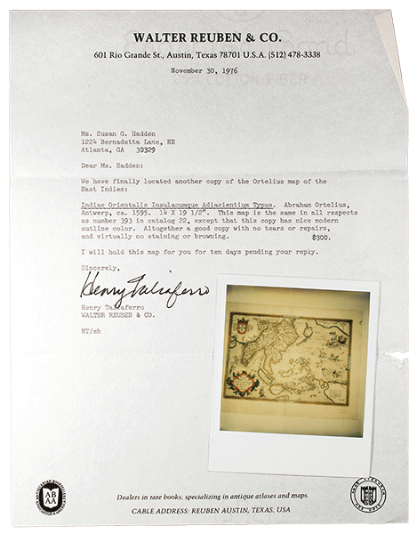
Typed letter with Polaroid photo
Correspondence and polaroid from Henry Taliaferro of Walter Reuben and Company to Susan G. Hadden, November 30, 1976. Susan G. Hadden Collection of Early Maps of India, Harry Ransom Center.

A letter from the previous year reveals that Hadden initially missed out on a copy of the Ortelius map mentioned above, one that had been on offer from the Austin-based bookseller Walter Reuben and Company. In a letter to Hadden, Reuben associate Henry Taliaferro writes, “We have finally located another copy of the Ortelius map of the East Indies,” offering it to her for $300. An off-center and somewhat blurry Polaroid photo of the map accompanies the letter, and two follow-up receipts—and, of course, the map itself—show that Hadden followed through with the purchase. One receipt suggests that she had been so eager to secure an Ortelius from Reuben that she put down a $100 deposit to ensure that she was offered the next one to become available.
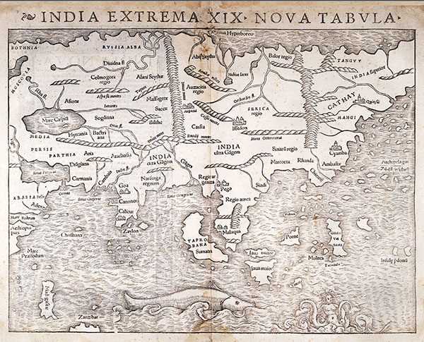
Early map of India
India extrema XIX nova tabula [map], in Geographia, by Ptolemy and Sebastian Münster (Basel: Henricus Petrus, 1540). Susan G. Hadden Collection of Early Maps of India,
Now at the Center, the Hadden maps supplement and extend our existing Kraus Map Collection, which features European maps and globes from the late Middle Ages to the end of the seventeenth century. We are confident these additions will prove to be an asset in University of Texas classes and to researchers. Two of the Hadden maps, in fact, have already been seen by thousands of visitors to the Center: We recently exhibited the Münster map of Asia and a section of a globe by Vincenzo Coronelli in our Stories to Tell gallery as part of “Printing the World in Premodern Europe.”

Dr. Aaron T. Pratt is the Carl and Lily Pforzheimer Curator of Early Books and Manuscripts at the Ransom Center.

Image: John Rapkin, British India [map], in The Illustrated Atlas, and Modern History of the World, ed. Robert Montgomery Martin (London: John Tallis and Company, ca. 1851). Susan G. Hadden Collection of Early Maps of India, Harry Ransom Center.

Filed Under: Books + Manuscripts, Featured1

About Aaron T. Pratt

Pratt oversees research, access, and interpretation of the Ransom Center’s pre-1700 books and manuscripts. His own research focuses on the literature and culture of the sixteenth and seventeenth centuries, bibliography, and the history of the book. He holds a Ph.D. in English Literature from Yale University.

Primary Sidebar

https://www.youtube.com/watch?v=C4_kazYMjNM

Recent Posts

  • Celebrate with us in 2023
  • Photographer Laura Wilson delves into the lives of writers with stunning portraits
  • A childhood gift inspires a lifelong passion for India and map-collecting
  • “Dog” by Lawrence Ferlinghetti
  • A Greek fragment is the first-known New Testament papyrus written on the front side of a scroll

Tags

acquisition Alice's Adventures in Wonderland archive archives Art Books Cataloging Conservation Council on Library and Information Resources David Foster Wallace David O. Selznick digitization exhibition Exhibitions Fellows Find Fellowships Film Frank Reaugh Frank Reaugh: Landscapes of Texas and the American West Gabriel Garcia Marquez Gabriel Garcia Marquez archive Gone with the Wind I have seen the Future: Norman Bel Geddes Designs America Lewis Carroll literature Magnum Photos Manuscripts Meet the Staff Nobel Prize Norman Bel Geddes Norman Mailer Performing Arts Photography poetry preservation Publishing Research Robert De Niro Shakespeare theater The King James Bible: Its History and Influence The Making of Gone With The Wind Undergraduate What is Research? World War I

Archives

Before Footer

Sign up for eNews

Our monthly newsletter highlights news, exhibitions, and programs.

Connect With Us

  • Facebook
  • Instagram
  • Twitter
  • YouTube

About

Ransom Center Magazine is an online and print publication sharing stories and news about the Harry Ransom Center, its collections, and the creative community surrounding it.

Copyright © 2023 Harry Ransom Center

Web Accessibility · Web Privacy