![]() Download the PDF (2.9MB)
Download the PDF (2.9MB)
Denise Schmandt-Besserat, Published in Javier Alvarez-Mon, Gian Pietro Basello, and Yasmina Wicks, The Elamite World, Routledge, London 2018.
Introduction
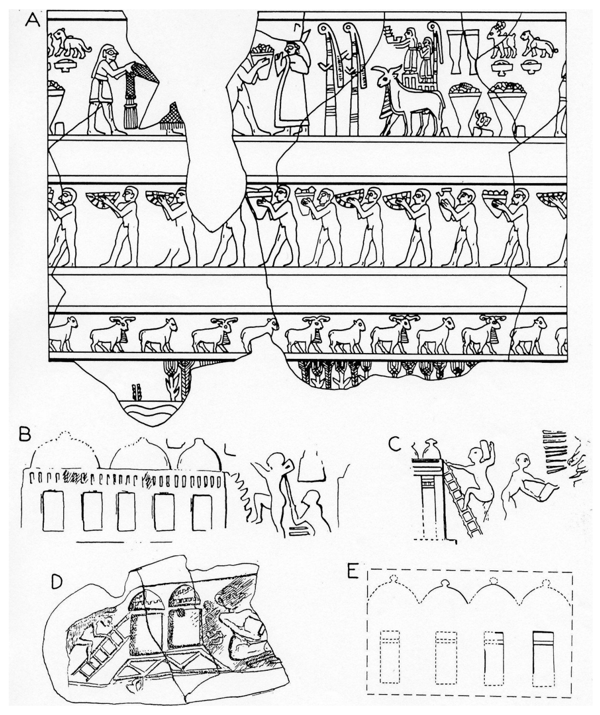
Ancient Near Eastern art of the 4th and 3rd millennium BC glorifies the temple redistribution economy. Mesopotamians are depicted proudly delivering vessels filled with goods at the temple gate (Leick 2002: 52–53; Nissen and Heine 2003: 30–31, Figure 20) (Figure 18.1 A), and Elamites celebrate their huge communal granaries (Amiet 1972b: Pl. 16:660, 662–663; Legrain 1921: Pl. 14: 222) (Figs. 18.1 B-E). What the monuments do not show is the judicious administration which managed the temple’s and community’s wealth. Nor do they tell when, how and why the redistribution system was created.
In this chapter we analyze what the prehistoric administrative technologies such as tokens and seals may disclose on the origin and evolution of the exemplary redistribution economy (Schmandt- Besserat 1992a: 172–183; Pollock 1999: 79–80, 92–96) which developed in antiquity in the land that was to become Elam (Vallat 1980: 2; 1993: CIV).
8th Millennium BC – Initial Village Period 1 – The First Tokens
The earliest human presence in the Susiana and Deh Luran plains – Greater Susiana (Moghaddam 2012a: 516) – was identified in level A of the site of Chogha Bonut, ca. 7200 BC. The evidence suggests the seasonal encampment of a small band who lived from farming as well as hunting (Alizadeh 2003:40). Among the scanty remains they left behind were ire pits dug into living floors and a scattering of artifacts, including flint and obsidian tools, rocks smeared with ochre, clay figurines and tokens (Alizadeh 2003: 35).
A century later, during the Bus Mordeh Period, ca. 7100 BC, the site Ali Kosh was a hamlet of sedentary farmers in the nearby Deh Luran Plain. It is not known where the Ali Kosh settlers came from, but what seems certain is that they arrived with locks of goats and sheep and with the knowledge of agriculture (Alizadeh et al. 2004: 71). This can be deduced from the fact that the large grain cereals they cultivated in their fields, such as emmer- wheat and two-row hulled barley, were not native to the region (Hole, Flannery and Neely 1969: 343). Twelve small clay spheres recovered in the Bus Mordeh levels are important, because they show that the Deh Luran farmers not only arrived with grains to cultivate but also with tokens to count.
As modest as they were, the 12 spheres of Ali Kosh provide important insights into the culture and economy of the early farming communities. First, they indicate the ability to count and therefore the cognitive capacity for management and administration. Second, they bring evidence that measures of grain were counted since, as is known from the signs of writing that derived from tokens, the sphere stood for a large measure of grain – perhaps a bushel (Schmandt-Besserat 1992a: 150–151). Archaeology cannot possibly reveal the motivation for counting bushels of grain in the 8th millennium BC. One is left to reason that counting, a demanding cognitive skill, was not acquired to merely calculate what farmers held in their family granary. It must have been for a more compelling reason. The fact that grain was the main staple, and that it could be stored over the lean season, made it the logical commodity to create a redistribution economy. And once such a redistribution economy was initiated, it required management. In the absence of other plausible reasons, we propose that the tokens of Chogha Bonut and Ali Kosh bring evidence that Greater Susiana was engaged in an economy of redistribution – a system of economic organization in which nonperishable food surpluses are collected and managed by an elite for redistribution for the community. The redistribution fulfills important communal functions, for instance, organizing banquets and rituals in honor of the gods (Schmandt- Besserat 2001: 399–400). Chogha Bonut and Ali Kosh thus borrow the token system, used by Mesopotamia and much of the Near East since the 8th millennium BC, to count and thereby control the collection and redistribution of communal goods. At its beginning in the region, of course, the operation would have been simple and modest, involving a number of households and perhaps headed by elders.
A farming redistribution economy was an extraordinary accomplishment in human cooperation. It was nothing less than the second greatest economic event in the evolution of mankind. The first was when our ancestors, the hunters, broke rank from the other primates by sharing their catches with the band (Wilson 2014: 22–23; Hayden 2014: 36). The cooperation of farmers to accumulate communal goods at the dawn of agriculture continued the millennia- old altruistic tradition of the hunters and gatherers. In both instances, sharing resources increased the chances of survival of the group. It is the farmers’ redistribution economy, however, that brought humans on a path leading to administration technologies, the increase of cognitive skills and ultimately writing and civilization.
7th Millennium BC – Initial Village Period – Neolithic Administrative Technologies
Farming and the corollary redistribution economy prospered in the entire Near East in the 7th millennium BC. In Deh Luran ca. 6900–6700 BC, the cultivated fields around the village of Ali Kosh became larger than those of the previous Bus Mordeh period. The houses increased in size to include multiple rooms. Pottery, the Neolithic craft par excellence, became part of the assemblage of the Mohammed Jaffar period, ca. 6700– 6500 BC. Obsidian trade from Turkey was well attested by 474 implements made of volcanic glass during the Ali Kosh period and 417 during that of Mohammed Jaffar (Hole, Flannery and Neely 1969: 105). Copper (from the Central Plateau?) was among the other traded materials represented in both periods, as well as turquoise (from northeastern Iran?), specular hematite (from Fars?) and sea shells (from the Persian Gulf?) (Hole, Flannery and Neely 1969: 242, 350, 353). Otherwise, the token collections of six spheres over the Ali Kosh period and two during that of Mohammed Jaffar showed no development and remained minimal (Hole, Flannery and Neely 1969: 230). Similar cultural changes in architecture and crafts took place in Susiana at Chogha Bonut B-E, ca. 6900–6700 BC. The token collection consisted of “plain tokens,” which were shared throughout the prehistoric Near East between the 8th and 4th millennium BC (Alizadeh 2003: 86–87, Figure 36) (Figure 18.2). These plain tokens were usually limited to four geometric types: cones, spheres, disks and cylinders, each with a few subtypes such as those listed below (Tab. 18.1). They were generally smooth- faced or, as in the case of Chogha Bonut, included rare examples which bore either nail impressions (3.16) or a few lines (3.40).
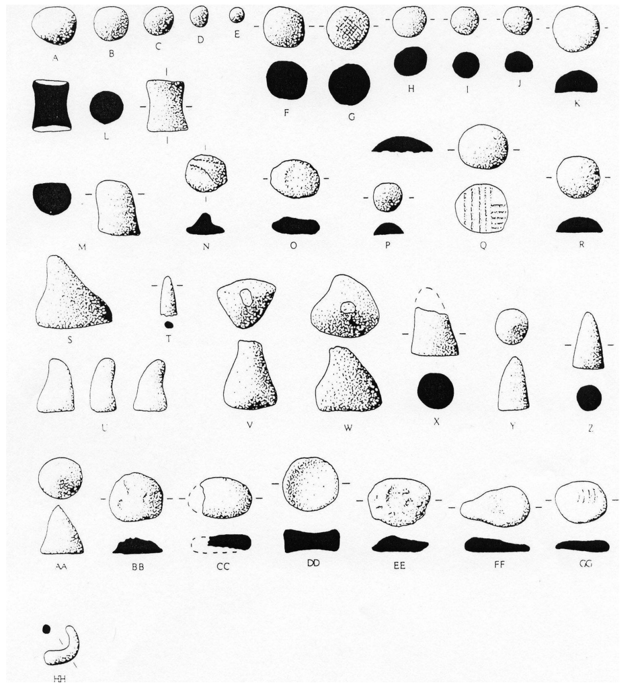
The Chogha Bonut assemblage differed from that of Ali Kosh in two major ways. First, the token collection was larger and more varied. Second, obsidian artifacts were rare (Alizadeh 2003:6). It is particularly interesting that Chogha Bonut and Ali Kosh show a striking lack of correlation between tokens and exchange. Ali Kosh was rich in traded goods but poor in tokens. On the contrary, Chogha Bonut, which showed no evidence of trade, had a substantial and diversified token collection. The same is true in other regions of the Near East. For example, in the Zagros Mountains of Iran, the early Neolithic site of East Chia Sabz received obsidian from Nemrut Dag and claims no tokens (Darabi and Glascock 2013: 3804–3809). But in contrast, Ganj Dareh Tepe, also in the Zagros, yielded no obsidian but produced a large token collection. Finally, Catal Huyuk, in Turkey, which derived its prosperity from the obsidian trade, produced few tokens. The fact that tokens cannot be linked to trade reinforces the notion that counting was used for no other function but the local management of goods. Furthermore, the addition to the token repertory of cones, discs and cylinders, standing, respectively, for small and very large measures of grain and small domestic cattle, further strengthens our hypothesis that counting originated for the control and management of farm products.
It is important to recognize that, as simple and archaic as they were, the plain tokens created a significant administration technology. The cones, spheres, disks and cylinders represented data. Their shape signified both the type of goods as well as the quantity dealt with. For example, a sphere stood for a large measure, perhaps a bushel of grain; a smaller unit – a pint (?) – was represented by a cone. The number of units of goods was shown by the number of tokens in one- to- one correspondence, three bushels of grain were shown by three spheres. The tokens were able to collect, store, communicate, organize and control data. For example, with the help of tokens, a leader could evaluate the yields of the forthcoming harvest; impose a levy on the estimated surplus and control the actual delivery of the goods. Once the collected grain was stored in the communal granaries and the global quantity calculated, the leader could allocate amounts for 1. Seeds; 2. The preparation of festivals; 3. Ritual offerings to the gods; 4. Subsistence in dire times. The fact that plain tokens were used in the entire Near East, with practically no change during three millennia, certainly attests to their usefulness and significance.
| Type I: Cone | Type II: Sphere | Type III: Disk | Type IV: Cylinder |
|---|---|---|---|
| 1.1: Isosceles 1.2: Equilateral 1.5: Large Equilateral 1.6: Flat | 2.1: Small 2.2: Large 2.24: Half- Sphere | 3.1: Flat 3.3: Lenticular 3.16: Nail Impressions 3.40: Sets of Lines and Strokes 3.81: High | 4.1: Tapering End |
6th–5th Millennium BC – Early and Middle Village Period – The Introduction of Stamp Seals
In the early 5th millennium BC, Chogha Mish adopted seals in its administration (Alizadeh 2008: 78). The site was then a settlement of 15 ha (Delougaz and Kantor 1996a: 280, 284), which loomed large in Susiana over the neighboring villages of Jaffarabad, Jowi and Bendebal. It was also the time when the first indication of industry appeared at Jaffarabad, in the form of pottery workshops (Dollfus 1971: 26–27).
The earliest seal assemblage of Chogha Mish consisted of three stamp seals and two sealings – the impression of seals on clay (Delougaz and Kantor 1996a: 256). The three stamp seals were small, measuring 1.5 to 2.1 cm. They were carved into round or square shapes in colorful orange, red and white stones. The three seals shared the same geometric design consisting of striated quadrants (Delougaz and Kantor 1996b: Pl. 234: GG, JJ, II). Interestingly, the design was not new, but was already popular in Mesopotamia (Amiet 1980: 256, Pl. 8:155). As for the two sealings, they bore the impression of a single seal featuring a rosette motif (Delougaz and Kantor 1996b: Pl. 67A-B). It is not known to what type of vessel or door they had been applied.
Like in Mesopotamia, where stamp seals were already used before the 7th millennium BC, the Susiana seals functioned in tandem with tokens to control the movement of goods within an administration (Alizadeh 2005: 17). The latter indicated the quality and quantity of goods dealt with; the former identified the authority or office in charge. The seals were applied onto jars, baskets and cases, to record the entry/exit of the merchandise they held into/from the collective storehouse. When placed onto a door, the sealing validated the delivery/retrieval of merchandise from a communal storehouse. One may expect that the number of tokens corresponding to the goods delivered or retrieved, were added or removed from the appropriate containers. The added control apparently did not cause any change in the usage of the plain token since the spheres continued to be the most popular counter of Chogha Mish, followed by cones and half- spheres (Delougaz and Kantor 1996a: 253–254; Alizadeh 2008: 77). Two spheres were the lot of Bendebal in level 12 and 16 (Dollfus 1983: 156), and a single cone at Djowi in Period II (Dollfus 1983: 42, 120, Figure 45:12).
It is likely that, at first, the seals served as status symbols and belonged exclusively to the leader(s). But with population increase, and the loss of face- to- face contacts between leaders and residents, the seals came to be used by subordinates on behalf of the leader(s). The addition of seals to the Chogha Mish administration may therefore signal the emergence of a more structured office capable of managing the increasing volume of the redistribution economy.
5th–4th Millennium BC (4200–3900 BC) – Late Village Period – Susa I – Acropole Levels 27–24 – The Introduction of a Temple Economy
One millennium later, when Chogha Mish was eclipsed following a conflagration (Kantor 1976: 27–29; Hole 1990: 6–7), it was Susa’s turn to take the lead in Susiana, when Jaffarabad (Dollfus 1975: 62), Jowi (Dollfus 1978: 156; 1983: 121) and Bendebal had become centers (Dollfus 1978: 153). Susa I was a settlement of some 15 ha, where industry was taking root with pottery workshops (Mecquenem 1943: 5). Most importantly, it boasted a temple built atop a monumental terrace (Canal 1978a: 32–38; Steve, Vallat and Gasche 2003: 398; Hole 2008: 167; Álvarez- Mon 2012: 742) where, no doubt, the leaders of the redistribution economy officiated.
The temple, and the terrace decorated with clay cones it stood upon (Canal 1978b: 173), demonstrated a quantum jump in the amount of resources collected from the community. It brings the evidence that, after 2,000 years, the redistribution system had reached a new level of magnitude. The Susa I temple had enough wealth to afford large expenditures for building and decorating monumental structures as well as supporting a large work force of architects, masons, carpenters and ceramicists (Wright and Johnson 1985: 25).
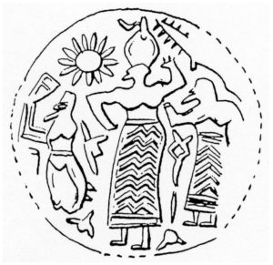
The Susa I temple also signified a change of social structure. The authority in charge of the administration was perhaps the figure depicted in glyptics sporting an imposing mitre and wearing a long embroidered kilt (Harper, Aruz and Tallon 1992: 43–44; Hole 2010: 233) (Figure 18.3). The personage, shown making awesome gestures between two submissive acolytes, may prefigure the powerful priest-king of the following Uruk and Susa II administration (Amiet 1986: 38). If the redistribution economy ever had been in lay hands, it clearly had shifted to the religious sphere.
One would expect that the transformation of the redistribution economy would lead to major administrative changes, but the people of Susa I still reckoned measures of cereals with exactly the same plain tokens, in the same shapes and sizes as in previous millennia. The cones recovered around the “Massif Funéraire” (Mecquenem 1943: 5, 8 and Figure 3: 15–16) continued to be modeled in clay and to be plain faced. Only the first appearance of a tetrahedron (Mecquenem 1943: 45–46 and Figure 40:2) considered to stand for a unit of labor (Schmandt- Besserat 1992a: 148, 150) offers faint but remarkable evidence of the workforce employed to build the monumental terraces. Also, the introduction of bitumen to manufacture tokens in level 2 of Jaffarabad, 1 cone and 2 spheres in bitumen (Dollfus 1971: 68 and Figure 27:4) against 1 cone, 7 spheres, 5 disks in clay (Dollfus 1971: 55), may be mentioned, although it would have no impact on management. Finally, Jaffarabad innovated painted markings on cone tokens (Dollfus 1971: 68 and Figs. 22, 15, 16).
Some may question whether the resources of the Susa I temple could be managed with tokens. The precolonial African kingdoms provide proof that sophisticated tax and conscription systems could be implemented with pebbles and shells (Herskovits 1938: 113–134). It remains to be acknowledged that the plain token assemblages from Greater Susiana were unusually small compared to those from Mesopotamia. For example, Arpachiyah produced 93 tokens of 11 types and 33 subtypes (Schmandt-Besserat 1992b: 155–162), and Tepe Gawra had 485 tokens in 11 types and 30 subtypes (Schmandt-Besserat 1992b: 240–255). In comparison, the complete collection of Jaffarabad, over its entire occupation, which represents the largest collection of Susiana, and Chagha Seid which represents the largest collection of Deh Luran (6000–5700 BC) (Hole 1977: 233, 237), only yield a total of 70 and 34 tokens, respectively. Eight types and 15 subtypes were represented in Jaffarabad, and three types and eight subtypes at Chagha Seid (Schmandt-Besserat 1992b: 23–27; 9–11). Moreover, how is one to explain that the Greater Susiana assemblages are poor compared to Iranian sites such as Zagheh, in the Qazvin plain of northern Iran, which contributed 238 tokens in seven types and 15 subtypes (Moghimi and Fazeli 2015: 37 and Tab. 2; Moghimi 2015: 136). Tall-e Geser (Alizadeh 2014: 45, Figure 88), in the neighboring Ram Hormuz area, is similarly no match for the even far earlier Neolithic site of Ganj Dareh Tepe, in the Zagros, with its 511 tokens, in seven types and 36 subtypes (Overmann n.d.). It is well possible that the reason for the discrepancy has nothing to do with the culture or economy of Susiana but simply with the excavations. Tokens are difficult to ind because they are minuscule and because their color blends with the ill. They are harder to detect in clay soils than in sandy terrains, and perhaps especially difficult to ind in the fertile compact earth of Khuzistan. The systematic use of sieves, which is not always possible, always enhances the chance of recovering the small artifacts. Finally, vigilance may play the most significant role. Vivian Broman, who was taking part in the Jarmo excavations when writing her thesis on clay artifacts, is to be thanked for the 2002 tokens recovered at the site – the largest collection ever assembled (Schmandt-Besserat 1992b: 176–179).
4th Millennium BC (3900–3500 BC) – Post Village Period – Susa II – Acropole I, Levels 23–19 / Early and Middle Uruk – The Complex Tokens and Urban Economy
After 2,000 years of unchanging plain tokens, the Susa II “complex tokens” came in many shapes and were covered with markings (Schmandt-Besserat 1992a: 73–88) (Figure 18.4). This brought the Susa collection of 783 tokens to multiply into 16 types and 178 subtypes (Schmandt-Besserat 1992b: 52–91) and the 813 tokens of Chogha Mish into 10 types and 45 subtypes (Delougaz and Kantor 1996a: 120–125, 1996b: Pl. 134). Complex tokens came in a diversity of new geometric as well as naturalistic shapes such as miniature vessels, tools and furniture. Markings in the form of sets of dots or parallel, perpendicular or criss- cross lines were another distinctive feature of the Susa II complex tokens. Finally, there were markings consisting of painting or appliqué pellets and coils. Perforation of some of the artifacts was yet another characteristic of the complex token assemblages. It is important to emphasize, however, that the plain tokens continued unchanged. The spheres, cones, disks and cylinders continued to be used smooth faced, as they had been all along, starting in Ali Kosh, and continuing through Chogha Bonut, Chogha Mish and Susa I.
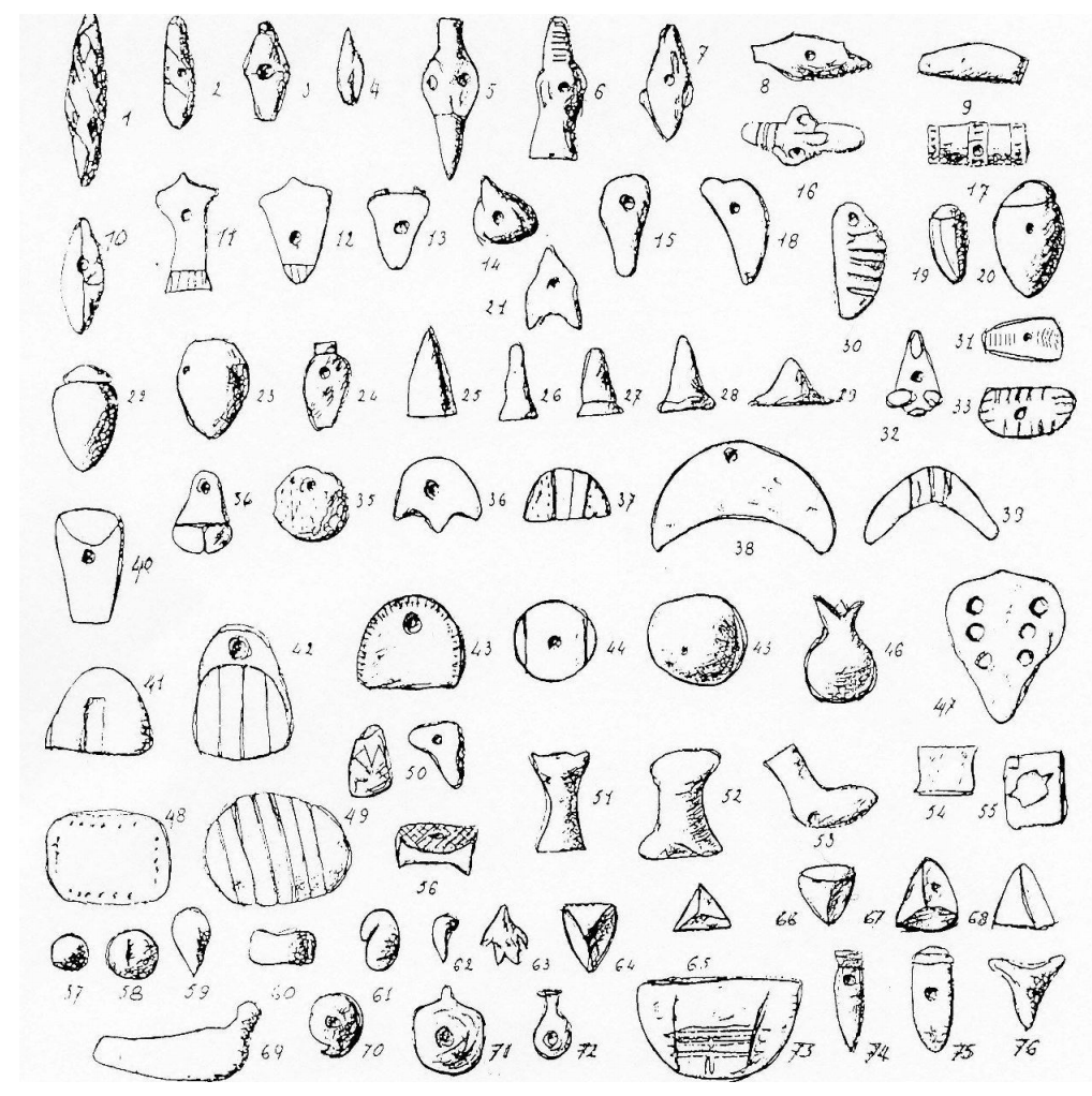
The complex tokens signaled major changes in the scope of the Susa II administration. First, they denoted a greater precision in accountancy. Whereas plain cylinders stood for one generic head of small cattle, the complex tokens used special markings to differentiate between rams, ewes and kids. There were also new tokens to refer to various cereals. Second, the complex tokens signified a vast increase in the range of products administered. Next to the plain tokens which stood for farm products, the complex tokens represented raw materials and manufactured goods (SchmandtBesserat 1992a: 143–149). There were tokens standing for wool, wood and metal. Others indicated finished products typical of urban workshops, such as various qualities of textiles and garments. The list of processed foods and drinks included beer, oil, bread, cakes and trussed ducks. There were also tokens to count types of vessels, tools and furniture, and finally, luxury goods such as perfume and jewelry. In other words, the administration of Susa II levied urban workshops and guilds.
It is important to realize that most Iranian sites of the 4th millennium BC never acquired complex tokens and continued to be limited to plain tokens. Such was the case for Farukhabad (Wright 1981: 156), Sharafabad (Wright, Miller and Redding 1980: 277), Tall- e Abu Chizan (KS 1663; Moghaddam 2012b: 131, Figure 5.28: 8–14, 29, 36), Tepe Mehr Ali (Sardari Zarchi and Rezaiee 2007: 19), in the southwest; Tepe Sialk (Ghirshman 1938), Qoli Darvish (Sarlak 2011) and Sofalin (Hessari 2011) in the Central Iranian Plateau; Tall-e Bakun in the south (Alizadeh 2005: 83–84, 252–255, Figs. 71–72) and Tepe Yahya (Mutin 2013: 150) in southeast Iran. Only five Iranian sites yielded complex tokens: Susa, Chogha Mish, Moussian (Schmandt- Besserat 1992b: 40–42), KS 54 (Johnson 1973: 92; 1976: 171–172; Schmandt-Besserat 1992b: 35–36) and Tepe Hissar II (Dyson 1987: 655–657; Thornton, Gursan-Salzmann and Dyson 2013: 141). With the exception of Hissar, all these sites were located in Greater Susiana. The complex token phenomenon in Iran may therefore be viewed as a mostly regional development of Greater Susiana.
Except for a group from the adjacent tell of the Ville Royale (Schmandt-Besserat 1992a: 84), the entire Susa token collection originated from the temple precinct on the Acropole mound – the administrative hub of the city (Steve and Gasche 1971: 41; Canal 1978a: 50; Álvarez-Mon 2013: 218). Office buildings decorated with clay cone mosaics were located towards the east (Dyson 1966: 269). The main concentration of tokens was recovered south of the shrine, where workshops and warehouses were located (Morgan et al. 1905: 40 Figs. 48 and 53; Belaiew 1933: 192–193,196, Figure 28; Mecquenem 1943: 27,29, Figure 23: 1–76). They were found together with administrative materials such as beveled rim bowls, serving as measures (Nissen 1988: 83–85), and sealings produced by the new type of cylinder seals (Amiet 1985: 37). These types of artifact and architecture decorations were typical of the administrative paraphernalia of Eanna, the temple precinct of the Mesopotamian goddess Inanna in the metropolis of the Uruk city state (Harper, Aruz and Tallon 1992: 50).
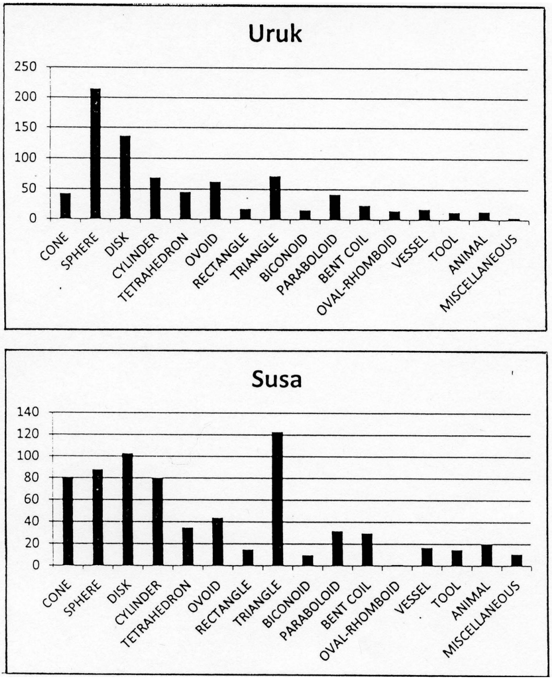
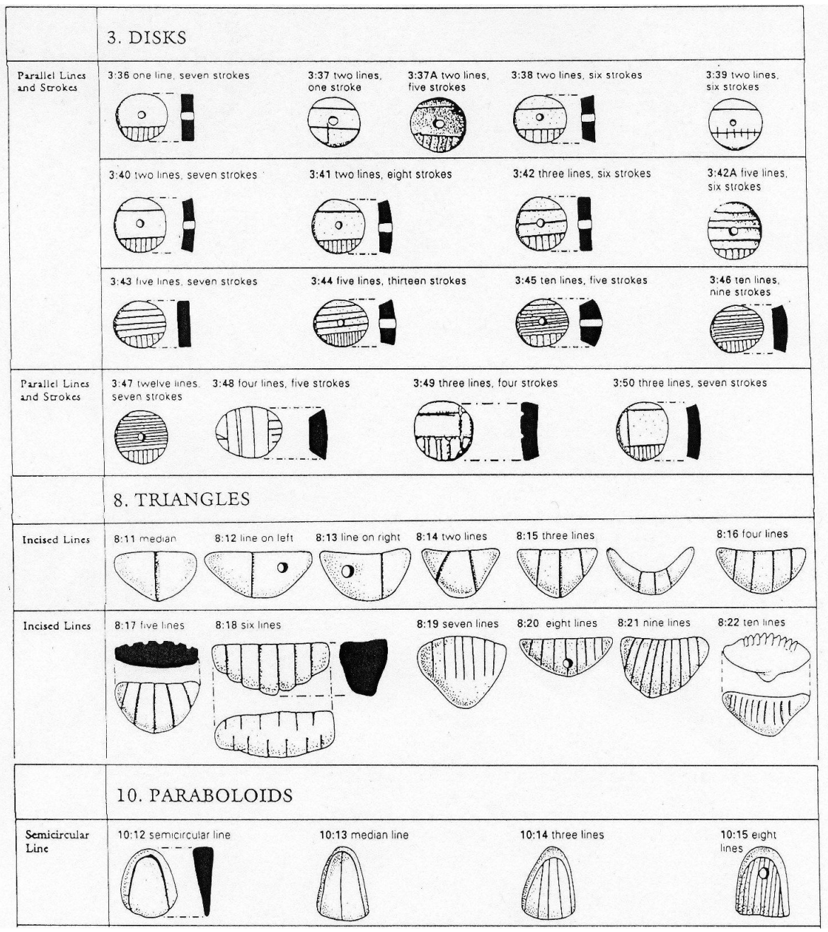
The token collection from Susa was remarkably similar to that from Uruk ( Figure 18.5). In particular, the two collections shared series of identical disks, triangles and paraboloids which indicated by a number of lines different qualities of a same product (Figure 18.6). For example, discs with 1, 3, 4, 5, 6, 8 and 10 lines stood for various types of cloth: and paraboloids with 0, 1, 3 or 8 lines denoted different models of kilts. Triangles with 5 lines, which represented an ingot of metal, were at both sites the most popular tokens of a series of triangles featuring 1, 2, 3, 4, 5, 6, 7, 8, 9 and 10 lines. The discrepancy between the Susa and Uruk token collections was chronological. At Uruk, complex tokens appeared in the Ubaid Period, ca. 4400 BC. They reached a floruit during Uruk VI to IV, ca. 3500–3300 BC. However, complex tokens did not occur at Susa before 3500–3300 BC. Accordingly, there can be no doubt that the leader in administrative technologies was Uruk (Carter and Stolper 1984: 113). There is presently no consensus on whether the transmission of complex tokens from Uruk to Susa occurred progressively or suddenly (Potts 1999: 52–59; Petrie 2013: 15). The fact that the levels of Susa I and II followed without transition and the traces of ire on the Acropole and Apadana mounds, however, seem to tilt the scale towards a brief episode (Amiet 1966: 66; Le Brun 1978b: 190; Steve and Gasche 1990: 20, 26).
Complex tokens were recovered at Uruk (Schmandt Besserat 1992a: 49–73) and Girsu (Schmandt-Besserat 1992b: 228–237) in Mesopotamia and as far west as Habuba Kabira (Schmandt-Besserat 1992a: 88–91) and Tell Kannas (Schmandt-Besserat 1992b: 373–377) in Syria. Although separated by several hundred miles from the Syrian sites, Susa and Chogha Mish shared with them the same ceramic vessels, cylinder seals, sealings and public architecture decorated with cone mosaics introduced from Uruk. In other words, the common denominator of the sites yielding complex tokens was an Uruk intervention (Nissen 1985: 39–40). The accounting techniques with complex tokens imported by the Uruk mega metropolis caused a quantum jump in the complexity of administration of Greater Susiana. The indigenous Susa I redistribution economy, managed with plain tokens, was based on an agricultural society. That of Uruk and Susa II vastly expanded to draw upon both agrarian and urban populations.
4th Millennium BC (3500–3300 BC) – Post Village Period – Susa II – Acropole I, Levels 18–17/Late Uruk – Envelopes and the Invention of Writing
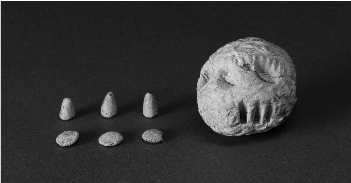
Envelopes to hold tokens were one of the most consequential inventions of the 4th millennium BC, since they led to the invention of writing. The envelopes consisted of hollow spherical or ovoid clay balls about 5–7 cm in diameter (Schmandt-Besserat 1992a: 110–128). The artifacts had thick walls, leaving a small cavity of 2–4 cm where tokens, representing records of contracts or debts, could be kept in archives. The number of tokens enclosed inside envelopes varied from two to 15. There was a majority of plain tokens, but all the tokens held in envelopes were of identical types and subtypes to those found loose.
Seven Iranian sites produced envelopes: Susa (Le Brun and Vallat 1978: 13–18, Figure 45, Pl. I-III; Le Brun 1978a: 62), Chogha Mish (Delougaz and Kantor 1996a: 120–121; 1996b: Pl. 133), Farukhabad (Wright 1981; 156), Sofalin (Hessari and Yusei Zoshk 2009: 21, Figure 13; Hessari 2011: 42, Figure 14), Qoli Darvish (Sarlak 2011: 204, Figure 28; Alizadeh, Aghili and Sarlak 2013: 161, Figure 14:11), Tepe Yahya (Schmandt-Besserat 1992b: 125–126, Figure 75) and Shahdad (Hakemi 1972: 20, 54, Pl. 22A). The three first sites are in Susiana, Sofalin and Qoli Darvish in the Central Iranian Plateau, and the two other sites are from the south- east. Susa produced 40 complete envelopes, 15 fragmentary and 57 fragments; Chogha Mish 25, plus four fragmentary and Farukhabad a single one (Schmandt-Besserat 1992a: 112– 114). The Faruhkabad and Chogha Mish examples are dated from the Middle Uruk period, ca. 3700–3500 BC (Schmandt- Besserat 1992a: 114). At Susa, envelopes are securely dated to level 18 and 17 of Acropole, equated to Eanna VI-V, ca. 3500–3300 BC (Vallat 1978: 193; Le Brun 1985: 35).
Helene Kantor noted that envelopes usually occurred in clusters (Delougaz and Kantor 1996a: 120). This must have been the case for the first envelopes discovered on the Susa Acropole, either by Jacques de Morgan in 1901 or Roland de Mecquenem in 1907 (Legrain 1921: 7–8, Pl. XIX:298; Mecquenem 1924: 106–107; 1943: 18–21, Figure 16). Like tokens, they belonged to the area of workshops and storehouses of the Susa II temple precinct (Amiet 1972a: 67), except for a unique exception in the north (Amiet 1972b: 92:549). Seventeen complete or fragmentary examples were located in 1977 in the ruins of an ordinary structure (Le Brun 1978c: 62–4; Le Brun and Vallat 1978: 13–18, Figure 3, Pl. I-III).
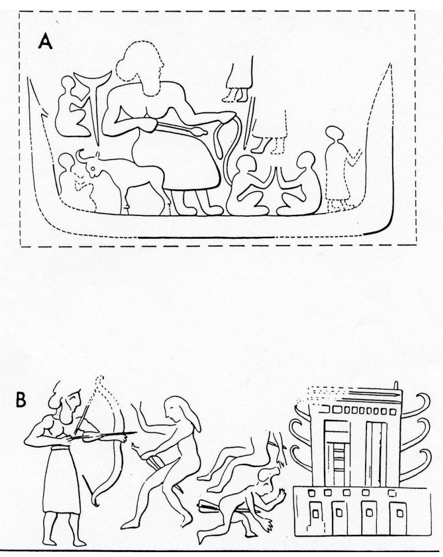
The envelopes finally combined tokens and seals together on the same artifact (Amiet 1972a: 69–70; 1972b: Pl. 61–88), each with a different purpose. Inside, the tokens stood for the quality and quantity of the goods dealt with; outside, the seals indicated the relevant authorities or offices involved. The typical Susa II seals in the shape of a small stone cylinder may have been invented specifically to be rolled around the envelopes. A single, two and even three different cylinder seal impressions systematically covered the entire surface of each envelope, but there are also examples of both stamp and cylinder seal impressions on the same envelope. Among the innumerable scenes carved on cylinder seals appears the “En,” the awesome priest- king of Uruk (Amiet 1986: 61), who was certainly heading the redistribution economy, since the sign for his title appears on the Uruk tablets (Green and Nissen 1987: 197). The personage is easy to identify by his size, greater than the rest of the mortals, and his unique round headdress and long skirt (Schmandt- Besserat 1993: 209–210). On an envelope from Chogha Mish, the “En” is depicted riding in a boat, holding two prisoners with a rope (Delougaz and Kantor 1996a: 146; 1996b: 151) (Figure 18.7A). At Susa, he stands in front of the temple, shooting arrows at Susians, recognizable by their long hair (Amiet 1972b: 18: 695) (Figure 18.7 B). Both compositions leave little doubt that the complex tokens and envelopes did not make their way from Uruk by peaceful trade.
The clay envelopes were helpful in keeping tokens and sealing together, thus preventing the tokens to be separated or lost. However, once the envelopes were closed, it was no longer possible to verify their content without breaking them and tampering with the sealings. It is for this reason that envelopes were marked by imprinting tokens on their surface while the clay was still soft (Figure 18.8). Markings were never used systematically. In Iraq, none of the 25 envelopes from Uruk were marked, but in Syria, both examples from Habuba Kabira were. In Iran, there were 12 marked envelopes in Susa and one in Tepe Yahya. Several of the envelopes of level 18 of Susa had markings, but those of the later level 17 did not.
Département des Antiquités Orientales, Paris.
The impressed markings indicated both the shape and number of tokens enclosed inside the envelopes. For example, three cones and three spheres were shown by three wedges and three circular markings, in one-to-one correspondence. The value of the impressed markings was the same as that of the tokens they represented: a wedge equaled the same small measure of grain as a cone token and a circular marking equaled the same large measure of grain as a sphere token. Three large and three small measures of grain, formerly indicated by three spheres and three cones became represented by three circular markings and three wedges. The function of the impressed markings was identical to that of the loose tokens. They communicated to accountants the exact same information, concerning small and large measures of grain, jars of oil and heads of small cattle. The markings served to manage the same goods in the same quantities for the same redistribution economy. This was the Susa II or Uruk redistribution economy celebrated by art (Figure 18.1A-E).
The markings on envelopes were an ingenious solution to a simple archival problem, but they forever changed accounting, management, administration and communication. The markings were the third metamorphosis in the 4,000-year evolution of tokens. Starting first with plain shapes, and secondly, evolving to complex forms, the tokens were finally reduced to two-dimensional impressed markings. This was writing: civilization was under way.
Conclusion
Cooperation is the hallmark of humanity (Wilson 2014: 28). Our hunter ancestors left behind all other primates by sharing resources rather than fighting for them. Sharing meat among hunters was simple and immediate. It took place upon the hunters’ return, as the game was butchered (Marshall 1976: 357–363). There was no need for counting since each cut was traditionally assigned to a particular individual of the band.
Sharing resources did not stop with the agriculture revolution. On the contrary, it further advanced when the first farmers initiated a redistribution economy mostly based on cereals and small cattle. The operation was complex because multiple households contributed and consumption was deferred over weeks or months. The new economy required a new leadership of managers able to administer the communal wealth by 1. Establishing the amounts of goods to be contributed by the community; 2. Controlling the deliveries; 3. Protecting the reserves from weather, rodents, raids and thieves; 4. Overseeing the redistribution. The leaders adopted tokens to count and control the communal resources at each step of the process.
The sites of Susiana and Deh Luran illustrate with surprising clarity the evolution of administrative technologies to implement the redistribution economy in Greater Susiana. Tokens were adopted at the same time as agriculture in the first levels of occupation of Ali Kosh and Chogha Bonut, ca. 7200 BC. Two millennia passed until the management of goods with plain tokens was complemented by stamp seals to communicate oficial information from an office or a person. The establishment of a temple at Susa, ca 4000 BC, did not cause any change in the plain tokens or stamp seals because it still relied on an agrarian economy. The next groundbreaking steps in administrative technologies – complex tokens and cylinder seals – came together to Greater Susiana from the neighboring Mesopotamian metropolis of Uruk. The new technologies were adapted to an urban economy.
The ancient Near Eastern redistribution economy should be viewed as a major landmark in the history of mankind. Its significance and complexity brought humans to count and discover the world of numbers. In turn, counting was the first cognitive step towards writing.
Acknowledgment
The chapter has been written in collaboration with Niloufar Moghimi, PhD candidate in the Prehistoric Archaeology of Iran, Department of Archaeology, the University of Tehran, moghimi.nilufar@ut.ac.ir. I am particularly grateful to Ms Moghimi for contributing her knowledge on the recent excavations in Iran. I also much appreciated her insights in the interpretation of the Susa token collection.
Note
1 I follow the chronological framework proposed by Moghaddam 2012a: 510 and 2012b: 4, Tab. 1.
Bibliography
Alizadeh, A. 2003. Excavations at the Prehistoric Mound of Chogha Bonut, Khuzestan, Iran, Seasons 1976/77, 1977/78 and 1996. Oriental Institute Publications 120. Chicago: The Oriental Institute of the University of Chicago.
———. 2005. The Origins of State Organizations in Prehistoric Highland Fars, Southern Iran: Excavations at Tall-e Bakun. Oriental Institute Publications 128. Chicago: The Oriental Institute of the University of Chicago.
———. 2008. Chogha Mish II, The Development of a Prehistoric Regional Center in Lowland Susiana, Southwestern Iran, Final Report on the last six seasons of excavations, 1972–1978. Oriental Institute Publications 130. Chicago: The Oriental Institute of the University of Chicago.
———. 2014. Ancient Settlement Systems and Cultures in the Ram Hormuz Plain, Southwestern Iran, Excavations at Tall-e Geser and Regional Survey of the Ram Hormuz Area. Oriental Institute Publications 140. Chicago: The Oriental Institute of the University of Chicago.
Alizadeh, A., Kouchouros, N., Wilkinson, T.J., Bauer, A.M. and Mashkour, M. 2004. Human Environment Interactions on the Upper Khuzestan Plains, Southwest Iran. Recent Investigations. Paléorient 30/1: 69–88.
Alizadeh, A., Aghili, S. and Sarlak, S. 2015. Highland- lowland Interaction in the Late 4th and Early 3rd millennium BCE: The Evidence from Qoli Darvish, Iranian Central Plateau. Archaologische Mitteilungen aus Iran and Turan 45: 149–68.
Álvarez-Mon, J. 2012. Elam: Iran’s First Empire. In: Potts, D.T. (ed.) A Companion to the Archaeology of the Ancient Near East. London: Blackwell, 740–57.
———. 2013. Khuzestan in the Bronze Age. In: Potts, D.T. (ed.) The Oxford Handbook of Ancient Iran. Oxford: Oxford University Press, 217–62.
Amiet, P. 1966. Elam. Auvers- sur- Oise: Archée Éditeur.
———. 1972a. Glyptique susienne des origines á l’époque des Perses Achéménides, Vol. I. Texte. Mémoires de la Délégation Archéologique en Iran 43. Paris: Paul Geuthner.
———. 1972b. Glyptique susienne des origines á l’époque des Perses Achéménides, Vol. II Planches. Mémoires de la Délégation Archéologique en Iran 43. Paris: Paul Geuthner.
———. 1980. La glyptique mésopotamienne archaique. Paris: Éditions du CNRS.
———. 1985. A propos de l’usage et de l’ioconographie des sceaux á Suse. Paléorient 11/2: 37–8.
———. 1986. L’age des échanges inter- iraniens 3500–1700 avant J.-C. Paris: Éditions de la Réunion des Musées Nationaux.
Belaiew, N.T. 1933. Métrologie Élamite, Examen Préliminaire des Documents Pondéraux, Fouilles de Suse 1921–1933. In: Scheil, V. Actes Juridiques Susiens, II. Inscriptions Achéménides. Mémoires de la Mission Archéologique de Perse 24. Paris: Librairie Ernest Leroux.
Canal, D. 1978a. La terrasse haute de l’Acropole de Suse. Cahiers de la Délégation Archéologique Francaise en Iran 9: 11–56.
———. 1978b. La Haute Terrasse de L’Acropole de Suse. Paléorient 4: 169–176. Carter, E. and Stolper, M.W. 1984. Elam: Surveys of Political History and Archaeology. Berkeley: University of California Press.
Darabi, H. and Glascock, M.D. 2013. The Source of Obsidian Artefacts Found at East Chia Sabz, Western Iran. Journal of Archaeological Science 40/10: 3804–3809.
Delougaz, P. and Kantor, H.J. 1996a. Chogha Mish Volume 1, The First Five Seasons of Excavations 1961–1971, Part 1: Text, edited by Abbas Alizadeh. Oriental Institute Publications 101. Chicago: The Oriental Institute of the University of Chicago.
———. 1996b. Chogha Mish Volume 1, The First Five Seasons of Excavations 1961–1971, Part 2: Plates, edited by Abbas Alizadeh. Oriental Institute Publications 101. Chicago: The Oriental Institute of the University of Chicago.
Dollfus, G. 1971. Les Fouilles á Djaffarabad de 1969 á 1971. Cahiers de la Délégation Archéologique Francaise en Iran 1: 17–161.
———. 1975. Les Fouilles á Djaffarabad de 1972 á 1974. Cahiers de la Délégation Archéologique Francaise en Iran 5: 11–220.
———. 1978. Djaffarabad, Djowi, Bendebal: Contribution á l’Etude de la Susiane au Ve Millénaire et au Début du IVe Millénaire. Paléorient 4: 141–167.
———. 1983. Djowi et Bendebal, Deux Villages de la Plaine Centrale du Khuzistan (Iran) (5e Millénaire avant J.C.). Cahiers de la Délégation Archéologique Francaise en Iran 13: 17–276
Dyson Jr., R.H. 1966. Excavations on the Acropolis at Susa and Problems of Susa A, B, and C. PhD Diss., Harvard University.
———. 1987. The Relative and Absolute Chronology of Hissar II and the Proto- Elamite Horizon of Northern Iran. In: Aurenche, O., Evin, J. and Hours, F. (eds.) Chronologies in the Gian Pietro Basello – L’Orientale University of Naples – 25/01/2018 — D e n i s e S c h m a n d t – B e s s e r a t — 380 Near East: Relative Chronologies and Absolute Chronology 16000–14000 B.P. BAR International Series 379 (II). Oxford: Archaeopress, 647–678.
Ghirshman, R. 1938. Fouilles de Sialk, I. Paris: Paul Geuthner.
Green, M.W. and Nissen, H.J. 1987. Zeichenliste der Archaischen Texte aus Uruk. Archaische Texte aus Uruk 2. Berlin: Gebr. Mann Verlag.
Hakemi, A. 1972. Catalogue de l’Exposition: Lut Xabis (Shahdad). In: Premier Symposium Annuel de la Recherche Archéologique en Iran. Teheran.
Harper, P.O., Aruz J. and Tallon, F. 1992. The Royal City of Susa. New York: The Metropolitan Museum of Art.
Hayden, B. 2014. The Power of Feasts from Prehistory to the Present. Cambridge: Cambridge University Press.
Herskovits, M.J. 1938. Dahomey: An Ancient West African Kingdom. Vol. 1. New York: J. J. Augustin
Hessari, M. 2011. New Evidence of the Emergence of Complex Societies Discovered on the Central Iranian Plateau. Iranian Journal of Archaeological Studies I/2: 35–48.
Hessari, M. and Yusei Zoshk, R. 2009. Emergence of Pre- Governmental Institution in the Central Plateau of Iran: Ruling Lords in the Proto- Elamite Period at Pishva’s Tepe Sofalin. Journal of Archaeological Studies 1/2: 1–22 (in Persian).
حصاری، مήتضی؛ یوسفی ίشک، رϭحاه. 1388 .پیدایش نϬادهاي پیش حکومتی در فات مήکزي ایήاϥ؛ خاϥ ساارهاي .آغاί ایامی در تپه سفالین پیشوا. مجله مطالعات باستانشϨاسی، دϭرϩ 1 / شϤارϩ 2 ،جلد 2 :1–2
Hole, F. 1977. Studies in the Archeological History of the Deh Luran Plain, The Excavation of Chagha Seid. Memoirs of the Museum of Anthropology, University of Michigan 9. Ann Arbor: University of Michigan.
———. 1990. Cemetery or Mass Grave? Reflections on Susa I. In: Vallat, F. (ed.) Contribution à l’histoire de l’Iran, Mélanges offerts à Jean Perrot. Paris: Editions Recherches sur les Civilisations, 1–14.
———. 2008. Ritual and the Collapse of Susa, ca. 4000 BC. Proceedings of the 5th International Congress on the Archaeology of the Ancient Near East: Madrid, April 3–8, 2006 (Vol.2). Madrid: Ediciones Universidad Autonoma de Madrid: Centro Superior de Estudios sobre el Oriente y Egipto, 165–178.
———. 2010. A Monumental Failure: The Collapse of Susa. In: Carter R.A. and Philip, G. (eds.) Beyond the Ubaid: Transformation and Integration in the late prehistoric societies of the Middle East. Studies in Ancient Oriental Civilization. Chicago: The Oriental Institute of the University of Chicago, 227–243.
Hole, F., Flannery, K.V. and Neely, J.A. 1969. Prehistory and Human Ecology of the Deh Luran Plain. Memoirs of the Museum of Anthropology 1. Ann Arbor: University of Michigan.
Johnson, G.A. 1973. Local Exchange and Early State Development in Southwestern Iran. Memoirs of the Museum of Anthropology 51. Ann Arbor: University of Michigan.
———. 1976. Uruk Villages on the Susiana Plain. Iran 14: 171–172.
Kantor, H. 1976. The Excavations at Chogha Mish, 1974–1975. In: Bagherzadeh, F. (ed.) Proceedings of the 4th Annual Symposium on Archaeological Research 4, Tehran: Iranian Center for Archaeological Research, 23–41.
Le Brun, A. 1978a. La Glyptique du Niveau 17B de l’Acropole (Campagne de 1972). Cahiers de la Délégation Archéologique Francaise en Iran 8: 61–79.
———. 1978b. Suse, Chantier “Acropole 1”. Paléorient 4: 177–192.
———. 1978c. Le Niveau 17B de l’Acropole de Suse (Campagne de 1972). Cahiers de la Délégation Archéologique Francaise en Iran 9: 57–154.
———. 1985. Le Niveau 18 de l’Acropole de Suse. Mémoires d’Argile, Mémoires du Temps. Paléorient 11/2: 31–36.
Le Brun, A. and Vallat, F. 1978. L’Origine de l’Écriture á Suse. Cahiers de la Délégation Archéologique Francaise en Iran 8: 11–59.
Legrain, L. 1921. Empreintes de Cachets Élamites Mémoires de la Mission Archéologique de Perse 16. Mission en Susiane. Paris: Ernest Leroux.
Leick, G. 2002. Mesopotamia, The Invention of the City. London: Penguin Books.
Marshall, L. 1976. Sharing, Talking, and Giving: Relief of Social Tensions among the !Kung. In: Lee, R.B. and De Vore, I. (eds.) Kalahari Hunter- Gatherers. Cambridge, MA: Harvard University Press, 349–371.
Mecquenem de, R. 1924. Fouilles de Suse (campagnes 1923–1924). Revue d’Assyriologie et d’Archéologie Orientale 21/3: 105–118.
———. 1943. Fouilles de Suse, 1933–1939. In: Mecquenem de, R., Contenau, G., Pister R. and Belaiew, N. (eds.) Archéologie Susienne. Mémoires de la Mission Archéologique en Iran 29 Mission de Susiane. Paris: Presses Universitaires de France, 3–161.
Moghaddam, A. 2012a. Southwestern Iran. In: Potts, D.T. (ed.) A Companion to the Archaeology of the Ancient Near East. London: Blackwell, 512–530.
———. 2012b. Later Village Period Settlement Development in the Karun River Basin, Upper Khuzestan Plain, Greater Susiana. Oxford: Bar International Series 2347.
Moghimi, N. 2015. An Archaeological Study on Accounting Systems in Prehistoric Human Societies of the Qazvin Plain: The Case of Tepe Zagheh. Journal of Archaeological Studies 7/1 issue 11: 127–146 (in Persian).
مقیϤی، نیلوفή .1394 .بήرسی باسΘانشϨاخΘی سامانه حδابداری در جوامع انδانی پیش اί تاریخ دشت قزϭین: مورد مطالعاتی .تپه ίاغه. مجله مطالعات باستانشϨاسی، دϭرϩ 7 / شϤارϩ 1 ،جلد 11 :127–4
Moghimi, N. and Fazeli, H. 2015. An Archaeological Study of the Tokens from Tepe Zagheh, Qazvin Plain, Iran. International Journal of the Society of Iranian Archaeologists 1/2: 30–42.
Morgan de, J., Jéquier, G., Mecquenem de, R., Haussoullier, B. and Graadt Van Roggen, D.L. 1905. Recherches Archéologiques. 2e série, Mémoires de la Délégation en Perse 7. Paris: Ernest Leroux.
Mutin, B. 2013. The Proto- Elamite Settlement and its Neighbors. Oxford: Oxbow books.
Nissen, H.J. 1985. Problems of the Uruk- Period in Susiana, Viewed from Uruk. Paléorient 11/2: 39–40.
———. 1988. The Early History of the Ancient Near East, 9000–2000 B. C. Chicago: The University of Chicago Press.
Nissen, H.J. and Heine, P. 2003. From Mesopotamia to Iraq. Chicago: The University of Chicago Press.
Overmann, K.A. (n.d.) Unpublished Token Catalogue, Cambridge, UK.
Petrie, C.A. 2013. Ancient Iran and its Neighbours: The State of Play. In: Petrie, C.A. (ed.) Ancient Iran and its Neighbours. British Institute of Persian Studies. Monographs Series III. Oxford: Oxbow books.
Pollock, S. 1999. Ancient Mesopotamia. Cambridge: Cambridge University Press.
Potts, D.T. 1999. The Archaeology of Elam. Cambridge: Cambridge University Press
Sardari Zarchi, A. and Rezaiee, A. 2007. Preliminary Report on the Archaeological Excavations at Tepe Mehr Ali Farsi, Summer and Fall 2006. Proceeding of Research Week. Iranian Center for Archaeological Research, ICHTO, Tehran, Iran: 13–19. (in Persian).
سήداری ίارچی، علیήضا؛ رضایی، عزیزه. (1385 .(گزارε مقدماتی کاϭشϬای باسΘانشϨاسی تپهمήϬعلی فارسی، تابΘδاϥ ϭ پائیز .1385 .در مجϤوعه مقاات هفΘه پژϭهش. پژϭهشکدϩ باسΘانشϨاسی کشور ایήاϥ ،تήϬاϥ :13–1
Sarlak, S. 2011. Archaeology and History of Qom. Qom: Shakhes publication, Cultural Heritage, Tourism and Handicrafts organization of Qom Province, Iran (in Persian).
سήلک، سیامک. 1390 .باسΘانشϨاسی ϭ تاریخ قم. ادارϩ کل میήاΙ فήهϨگی، صϨایع دسΘی ϭ گήدشگήی اسΘاϥ قم: انΘشارات .شاخص
Schmandt- Besserat, D. 1992a. Before Writing 1 From Counting to Cuneiform. Austin: The University of Texas.
———. 1992b. Before Writing 2 A Catalogue of Near Eastern Tokens. Austin: The University of Texas.
———. 1993. Images of Enship. In: Frangipane, M., Hauptmann, H., Liverani, M., Matthiae, P. and Mellink, M. (eds.) Between the Rivers and Over the Mountains. Rome: Universita di Roma “La Sapienza”. Dipartimento di Scienze Storiche Archeologiche e Antropologiche dell’Antichita, 201–219.
———. 1996. How Writing Came About. Austin: The University of Texas Press.
———. 2001. Feasting in the Ancient Near East. In: Dietler, M. and Hayden, B. (eds.) Feasts, Archaeological and Ethnographic Perspectives on Food, Politics, and Power. Washington: Smithsonian Institution Press, 391–403.
Steve, M.-J. and Gasche, H. 1971. L’Acropole de Suse, Nouvelles Fouilles. (Mémoires de la Délégation Archéologique en Iran, Mission de Susiane 46) Paris: Paul Geuthner.
Steve, M.-J. and Gasche, H. 1990. Le Tell de l’Apadana avant les Achéménides. In: Vallat, F. (ed.) Contribution à l’histoire de l’Iran, Mélanges offerts à Jean Perrot. Paris: Editions Recherche sur les Civilisations, 15–32.
Steve, M.-J., Vallat, F. and Gasche, H. 2003. La Découverte de Suse: Les données archéologiques. Dictionnaire de la Bible. Supplément 73: 375–403.
Thornton, C.P., Gursan- Salzmann, A. and Dyson Jr., R.H. 2013. Tepe Hissar and the Fourth Millennium of North- Eastern Iran. In: Petrie, C.A. (ed.) Ancient Iran and its Neighbours. British Institute of Persian Studies, Archaeological Monographs Series III. Oxford: Oxbow Books, 131–144.
Vallat, F. 1978. Le Matériel Épigraphique des Couches 18 á 14 de l’Acropole. Paléorient 4: 193–195.
———. 1980. Suse et l’Elam. Recherche sur les grandes civilisations, Études Élamites. Mémoire 1. Paris: Editions ADPF.
———. 1993. Répertoire Géographiques des Textes Cunéiformes XI. Wiesbaden: Dr. Ludwig Reichert Verlag.
Wilson, E.O. 2014. The Meaning of Human Existence. London: Liveright Publishing Corporation.
Wright, H.T. 1981. An Early Town in the Deh Luran Plain: Excavations at Tepe Farukhabad. Memoirs of the Museum of Anthropology 13. Ann Arbor: The University of Michigan.
Wright, H.T. and Johnson, G.A. 1985. Regional Perspectives on Southwest Iranian State Development. Paléorient 11/2: 25–30.
Wright, H.T., Miller, N. and Redding, R. 1980. Time and Process in an Uruk Rural Center. In: Barrelet, M.T. (ed.) L’Archéologie de l’Iraq au Début de l’Époque Néolithique A 333 Avant Notre Ère. Colloques Internationaux du Centre National de la Recherche Scientifique No. 580. Paris: Éditions du Centre National de la Recherche Scientifique, 265–282.
Page last updated: 1/19/21